Category:16th-century maps of Maastricht
English: Maps of Maastricht made in the 16th century.
Subcategories
This category has the following 3 subcategories, out of 3 total.
M
Media in category "16th-century maps of Maastricht"
The following 8 files are in this category, out of 8 total.
-
 Jezuïetenklooster Maastricht, plan ca 1595.jpg 3,539 × 2,459; 4.23 MB
-
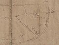 Kaart Vroenhof, 1585 (RAL K 151) (detail Kanjel & Meerssenerweg).jpg 2,631 × 2,015; 1.75 MB
-
 Kaart Vroenhof, 1585 (RAL K 151).jpg 5,084 × 3,727; 1.96 MB
-
 Map Siege of Maastricht 1579 (cropped).jpg 708 × 358; 113 KB
-
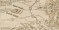
 Map Siege of Maastricht 1579.jpg 1,511 × 1,791; 1.08 MB
-
 Wolf-Dietrich-Klebeband Städtebilder G 034 III (cropped).jpg 1,335 × 685; 553 KB
-
 Wolf-Dietrich-Klebeband Städtebilder G 034 III (Nieuwstad).jpg 283 × 183; 32 KB
-
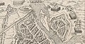
 Wolf-Dietrich-Klebeband Städtebilder G 034 III.jpg 2,000 × 1,543; 1.55 MB

_(detail_Kanjel_%26_Meerssenerweg).jpg)
.jpg)
.jpg)

.jpg)
.jpg)
