Category:1700 maps of Quebec
Provinces and territories of Canada: Quebec ·
| 1700 1702 1704 1709 |
English: Maps of Quebec from 1700 or related to Quebec in 1700
Français : Les cartes du Quebec de 1700 ou se rapportant au Quebec en 1700
Media in category "1700 maps of Quebec"
The following 2 files are in this category, out of 2 total.
-
 CarteIsleMontreal1700.jpg 1,619 × 1,017; 1.45 MB
-
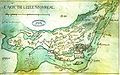
 Lac à la Loutre Montréal.jpg 1,014 × 745; 921 KB

