Category:1710 maps
| ← · 1710 · 1711 · 1712 · 1713 · 1714 · 1715 · 1716 · 1717 · 1718 · 1719 · → |
Deutsch: Karten mit Bezug zum Jahr 1710
English: Maps related to the year 1710
Español: Mapas relativos al año 1710
Français : Cartes concernant l’an 1710
Русский: Карты 1710 года
Subcategories
This category has the following 6 subcategories, out of 6 total.
Media in category "1710 maps"
The following 52 files are in this category, out of 52 total.
-
-

-

-
 1710-Wien-Steinhausen-Roter Turm.jpg 909 × 317; 109 KB
-

-

-
 A plan of the Isle of Portland and parts adjacent 1710.png 4,380 × 2,567; 17.97 MB
-
 Adam Friedrich Zürner, Terra Sancta s.Palaestina oder das Gelobte Land (FL199398053 2369196).jpg 4,184 × 5,712; 16.45 MB
-
 Andaluzia - Gabriel Bodenehr.jpg 1,020 × 644; 121 KB
-
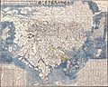
 Asia - qua nulla beatior ora ; tractus in eoos vergens mundique teporem.png 7,066 × 5,793; 77.18 MB
-

-
 Cartina Monteleone 1710.jpg 2,042 × 1,712; 1.3 MB
-

-
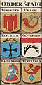
 Ducatus Wurtenbergici 1 (Detail).jpg 1,056 × 1,056; 1.16 MB
-
 Ducatus Wurtenbergici 1.jpg 3,350 × 4,010; 8.16 MB
-
 Ducatus Wurtenbergici 2 cropped.jpg 338 × 674; 376 KB
-
 Ducatus Wurtenbergici 2.jpg 3,357 × 4,023; 7.75 MB
-
 Ducatus Wurtenbergici in totum.jpg 6,706 × 4,073; 15.96 MB
-
 Elias Baeck, Palaestina, das Gelobte Land, oder Heilige Land (FL200036749 2368347).jpg 4,030 × 3,000; 7.91 MB
-

-

-

-
 Jean Leclerc, Iter Israelitarum per Arabicas solitudines (FL45602037 3935123).jpg 4,646 × 3,484; 3.73 MB
-

-

-
 Johann Christoph Steinberger, South Asia (FL35865337 2491854).jpg 5,500 × 8,830; 60.79 MB
-

-
 Johann Ludwig Gleditsch, Reisen der Patriarchen (FL45611852 3950697).jpg 2,924 × 2,308; 1.96 MB
-

-
 Karte Schlesien von Petrus Schenk 1710 flächenkoloriert.jpg 3,882 × 3,294; 3.04 MB
-
 Karte Schlesien von Petrus Schenk 1710.jpg 3,971 × 3,333; 3.16 MB
-
 Map Vienna 1710.jpg 3,840 × 4,012; 4.21 MB
-
 Nansenbushū bankoku shōka no zu LOC 96685908.jpg 17,400 × 14,208; 33 MB
-
 Nansenbushū bankoku shōka no zu LOC 96685908.tif 17,400 × 14,208; 707.3 MB
-

-
 Nicolaes Visscher II, Nouvelle carte de la Mer Noire et du Canal de Constantinople (FL36011251 2878085).jpg 14,271 × 11,956; 230.28 MB
-

-
 PatentMap.jpg 448 × 330; 84 KB
-
 Peter Schenk the Younger, La Russie blanche ou Moscovie (FL36379279 2606418).jpg 14,982 × 12,626; 283.99 MB
-

-
 Pierre Moullart-Sanson, Description geographique de la Terre Promise (FL35080858 3888727).jpg 9,810 × 9,738; 130.7 MB
-
 Plan af København 1710.jpg 4,938 × 3,591; 1.66 MB
-

-
 RamapoughVillage.jpg 382 × 452; 98 KB
-
 Syria et Palaestina (FL36559274 3901654).jpg 3,649 × 4,469; 23.85 MB
-
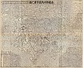
 Tabula Altera quæ Continet Potissima Asiæe (FL36011214 2819766).jpg 10,437 × 9,772; 135.41 MB
-

-

-

-
 Terra sancta das gelobte land (FL45611855 3950705).jpg 2,136 × 2,680; 1.81 MB
-
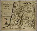 Thomas Godwyn, Geographia Terræ Canaan (FL48326236 3954774).jpg 3,500 × 3,003; 11.39 MB
-


.jpg)
.jpg)

.jpg)


.jpg)

.jpg)
.jpg)


.jpg)
.jpg)
.jpg)

.jpg)
.jpg)
.jpg)
.jpg)
.jpg)
.jpg)


.jpg)
.jpg)

.jpg)
.jpg)
.jpg)

.jpg)

.jpg)
.jpg)
.jpg)

.jpg)
.jpg)
.jpg)