Category:1710s maps of Puerto Rico
States of the United States: Delaware · Florida · Louisiana · Maine · Maryland · Massachusetts · Michigan · New Jersey · New York · North Carolina · Pennsylvania · South Carolina · Virginia
Puerto Rico
Puerto Rico
Media in category "1710s maps of Puerto Rico"
The following 2 files are in this category, out of 2 total.
-
 1712 detail Porto Rico map by Johannes van Keulen BPL m8719.png 3,052 × 1,059; 6.5 MB
-
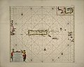 1712 Porto Rico map by Johannes van Keulen BPL m8719.jpg 6,389 × 5,095; 9.72 MB
