Category:1741 maps of Europe
English: 1741 maps of Europe
Español: Mapas de Europa en 1741
Suomi: Euroopan kartat vuodelta 1741
Română: Hărți ale Europei din 1741
Subcategories
This category has the following 3 subcategories, out of 3 total.
Media in category "1741 maps of Europe"
The following 15 files are in this category, out of 15 total.
-
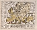
 1741 linguistic maps of Europe, Asia, Africa and the Americas by Gottfried Hensel.jpg 3,397 × 2,806; 12.35 MB
-

-
 1741 maps of Europe, Asia, Africa and America showing the distribution of languages.jpg 3,910 × 3,507; 2.16 MB
-

-
 Europa polyglotta - Terra polyglotta (cropped).jpg 3,428 × 2,791; 2.14 MB
-
-
 Europa Polyglotta.jpg 1,593 × 1,279; 472 KB
-

-
 Gottfried Hensel's linguistic map of the world, 1741.jpg 1,600 × 1,322; 894 KB
-
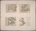
 Hensel 1741 4maps.jpg 1,744 × 1,400; 2.41 MB
-
 Hensel Polyglot, Maps of the Continents 1741 Cornell CUL PJM 1022 01.jpg 6,333 × 5,440; 4.29 MB
-
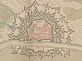 Plan de Thionville 1741 (cropped).jpg 5,803 × 4,353; 3.39 MB
-
 Plan de Thionville 1741.jpg 10,762 × 7,951; 10.12 MB
-
 Polyglot Maps of Asia, Europe, Africa and the Americas by Gottfried Hensel.jpg 6,333 × 5,440; 5.86 MB
-
 Terra polyglotta.jpg 7,952 × 7,210; 9.91 MB


.jpg)


.jpg)


.jpg)


