Category:1747 maps of Africa
Temperate regions: North America · South America · Africa · Europe · Asia · – Polar regions: – Other regions:
| ← 1740 1741 1742 1743 1744 1745 1746 1747 1748 1749 → |
Media in category "1747 maps of Africa"
The following 51 files are in this category, out of 51 total.
-
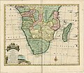 1455808337AnewandaccuratemapofthesouthernpartsofAfricaREDUCED.jpg 2,260 × 1,957; 1.51 MB
-
 1747 Ratelband Map of Gibraltar - Geographicus - Gibraltar-ratelband-1747.jpg 5,000 × 2,033; 1.39 MB
-
-

-
-
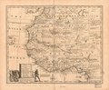
 A new and accurate map of Negroland and the Adjacent Countries.jpg 8,910 × 7,764; 14.34 MB
-
 Africa North 1747, Emanuel Bowen (4006898-recto).jpg 5,826 × 4,715; 4.51 MB
-
 AMH-6328-KB Map of a stretch of the West African coast.jpg 2,400 × 1,961; 761 KB
-

-

-
 AMH-7882-KB Map of Cape Verde with a view of the island of Goeree.jpg 1,696 × 2,400; 597 KB
-

-

-
 AMH-7888-KB Map of the island of Goeree.jpg 2,400 × 1,794; 788 KB
-
 AMH-7889-KB Bird's eye view of Goeree.jpg 2,400 × 1,405; 705 KB
-
 AMH-7892-KB Map of part of the west coast of Africa, near Cape Verde.jpg 1,742 × 2,400; 719 KB
-
 AMH-7893-KB Map of part of the west coast of Africa, near the Senegal river.jpg 1,723 × 2,400; 607 KB
-
 AMH-7894-KB Map following the course of the Senegal river, in two parts.jpg 2,400 × 1,884; 849 KB
-
 AMH-7895-KB Map of the mouth of the Senegal river.jpg 1,700 × 2,400; 592 KB
-
 AMH-7905-KB Map of the mouth of the Senegal river.jpg 1,715 × 2,400; 727 KB
-
 AMH-7923-KB Map of part of the African east coast and Madagascar.jpg 2,400 × 2,115; 933 KB
-
 AMH-7925-KB Map of part of the east coast of Africa.jpg 1,798 × 2,399; 735 KB
-
 AMH-7926-KB View of Table Bay featuring a map of the bay and the fort.jpg 1,773 × 2,400; 823 KB
-
 AMH-7932-KB Map of part of the West African coast.jpg 2,400 × 1,779; 756 KB
-
 AMH-7934-KB Map of the coast of Sierra Leone to Cape Mount.jpg 1,611 × 2,400; 649 KB
-
 AMH-7943-KB Map of the West African coast, from Cape das Palmas to Cape Tres Puntas.jpg 2,400 × 1,755; 642 KB
-

-
 AMH-7945-KB Map of the Gold Coast.jpg 2,400 × 1,352; 687 KB
-
 AMH-7950-KB Bird's eye view of the European trading posts at Sabi.jpg 2,400 × 1,759; 1.11 MB
-
 AMH-7951-KB Map of the Benin Gulf.jpg 2,400 × 1,733; 719 KB
-
 AMH-7952-KB Map of the Comoros.jpg 2,400 × 2,159; 787 KB
-

-
 AMH-7954-KB Bird's eye view of Loango.jpg 2,400 × 1,885; 1.16 MB
-
 AMH-7955-KB Map of the coasts of Congo, Angola and Benguela.jpg 2,400 × 1,944; 969 KB
-
 AMH-7956-KB Map of the mouth of the Congo River.jpg 1,723 × 2,400; 594 KB
-
 AMH-7957-KB Map of part of the Angolan coast.jpg 2,400 × 1,913; 677 KB
-
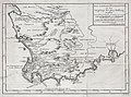
 AMH-7959-KB Map of Saldanha Bay.jpg 2,400 × 1,901; 886 KB
-
 AMH-7961-KB Map of Cape Town and the fort De Goede Hoop (Good Hope).jpg 2,400 × 2,036; 1.09 MB
-
 AMH-7964-KB Map of part of Mozambique.jpg 2,400 × 2,050; 839 KB
-

-

-
 L'Afrique suivant les dernières observations de M. Hass et des RR. PP. Jésuites - btv1b8468356m.jpg 10,546 × 8,172; 13.24 MB
-
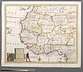
 New & Accurate Map of Negroland - DPLA - 4c1e7a939c99adfc779e5ac80ada9d1d.jpg 1,000 × 780; 256 KB
-
 New & Accurate Map of Negroland.jpg 4,000 × 3,117; 3.09 MB
-

-
 New and Accurate Map of Africa - DPLA - 3e0d159481f069c04e6570ac7c063bb7.jpg 1,000 × 838; 222 KB
-

-
 Resized-inu-afrmap-4004357-recto-master.png 3,695 × 3,111; 19.99 MB
-
 Resized-inu-afrmap-4004497-recto-master.png 3,733 × 3,064; 19.99 MB
-
 Resized-inu-afrmap-4006782-recto-master.png 3,736 × 3,055; 20 MB
-


.jpg)


.jpg)


.jpg)


_-_btv1b8595586k.jpg)