Category:1760s maps of England
Constituent countries of the United Kingdom: England
Subcategories
This category has the following 5 subcategories, out of 5 total.
Media in category "1760s maps of England"
The following 4 files are in this category, out of 4 total.
-

-
 Cranbrook 1761.jpg 429 × 431; 100 KB
-
 London-Harwich 1766.jpg 1,100 × 680; 762 KB
-
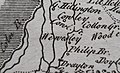 Wewesley (Yiewsley) John Rocque Middlesex 1769.jpg 1,675 × 1,015; 515 KB


_John_Rocque_Middlesex_1769.jpg)