Category:1773 maps
| ← 1770 1771 1772 1773 1774 1775 1776 1777 1778 1779 → |
Deutsch: Karten mit Bezug zum Jahr 1773
English: Maps related to the year 1773
Español: Mapas relativos al año 1773
Français : Cartes concernant l’an 1773
Русский: Карты 1773 года
Subcategories
This category has the following 5 subcategories, out of 5 total.
Media in category "1773 maps"
The following 46 files are in this category, out of 46 total.
-

-
 1773 map of portsmouth showing the town and dock defences.JPG 1,856 × 2,247; 2.62 MB
-
 1773 map, Chalmandrier - plan de Genève (cropped).jpg 663 × 531; 220 KB
-

-

-

-

-

-
 A New map of the island of Jamaica, from an actual survey. LOC 73691848.jpg 5,964 × 4,320; 2.95 MB
-
 A New map of the island of Jamaica, from an actual survey. LOC 73691848.tif 5,964 × 4,320; 73.71 MB
-
 A plan and chart of Lisbon - Setuval and its neighbouring country. RMG F0079.tiff 7,314 × 5,891; 123.27 MB
-
 A plan of Port Royal in South Carolina. LOC 74692650.jpg 7,136 × 8,832; 8.89 MB
-
 A plan of Port Royal in South Carolina. LOC 74692650.tif 7,136 × 8,832; 180.32 MB
-
 A plan of the river and sound of D'Awfoskee in South Carolina. LOC 74692651.jpg 6,696 × 9,139; 6.01 MB
-
 A plan of the river and sound of D'Awfoskee in South Carolina. LOC 74692651.tif 6,696 × 9,139; 175.08 MB
-
 A plan of the river and sound of DAwfoskee in South Carolina (8249819623).jpg 1,439 × 2,000; 2.42 MB
-
 AMH-8050-KB Map of the mouth of the Poumaron.jpg 1,824 × 2,400; 862 KB
-
 AMH-8053-KB Map of the mouth of the Copename and Sarameca River.jpg 1,773 × 2,400; 863 KB
-
 Baksidan ”Carta öfver Dantzig” - Skoklosters slott - 99044.tif 3,358 × 4,273, 2 pages; 41.08 MB
-
 Bellin - Carte de la Tartarie Occidentale.png 1,987 × 1,500; 4.91 MB
-
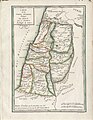
 Carte des Douze Tribus D'Israel (FL45583041 3926741).jpg 2,615 × 2,411; 1.67 MB
-

-
 Chart of the Island Otaheite, by Lieut. J. Cook 1769. RMG F0086.tiff 5,160 × 3,488; 51.49 MB
-
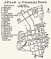 Cook, James — 1773 Map of Charles Town.jpg 1,366 × 1,600; 670 KB
-
 Corsham map 1773.jpg 800 × 580; 154 KB
-
 First map of Sevastopol Bay by Ivan Baturin 1773.jpg 2,272 × 1,704; 365 KB
-
 Carte des chasses Villetaneuse.JPG 579 × 862; 290 KB
-
-
-
-
 Mapaantiguaguatemala1773.jpg 1,293 × 878; 539 KB
-
 NL-HaNA 4.VEL 649-groot.jpg 8,192 × 3,113; 14.02 MB
-

-

-
 Samuel Wallis map of Boscawen and Keppel islands (Tafahi and Niuatoputapu).jpg 2,339 × 2,464; 2.51 MB
-

-

-

-
 The BL King’s Topographical Collection- "(Map of part of the Rhine-Meuse delta).".jpg 4,000 × 2,955; 2.34 MB
-

-
 Tiszai hajózási térkép 1773.jpg 453 × 600; 55 KB
-
 UBBasel Map 1773 Kartenslg Mappe 96-3 Roma.tiff 12,543 × 8,144, 2 pages; 292.28 MB
-
 Wien 1773 Nagel Praterstern genordet.jpg 1,200 × 1,073; 1 MB
-
 Willem Albert Bachiene, Nieuwe en Naukeurige Kaart van Asia (FL27958400 2485161).jpg 14,189 × 11,319; 218.19 MB
-
 Zhejiang quan tu LOC gm71005029.jpg 12,522 × 7,747; 10.4 MB
-
 Zhejiang quan tu LOC gm71005029.tif 12,522 × 7,747; 277.54 MB


.jpg)


.jpg)


.jpg)
tre_de_math%C3%A9matiq(ue)_-_btv1b106785540.jpg)


.jpg)


.jpg)
.jpg)

.%22.jpg)


.jpg)
