Category:1780s maps showing history
Media in category "1780s maps showing history"
The following 15 files are in this category, out of 15 total.
-
 1782 d'Anville Map of the Eastern Roman Empire - Geographicus - RomanEmpireEast-anville-1782.jpg 4,831 × 6,000; 10.19 MB
-

-
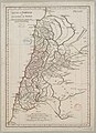
 Antique Map of Classical City of Sparta.jpg 2,218 × 2,071; 2.51 MB
-
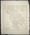 Graecia Antiqua.jpg 7,243 × 8,554; 14.5 MB
-

-

-

-
-
-
 A Map of the Beacons in Kent (BM 1872,0113.1137).jpg 2,467 × 1,925; 860 KB
-

-
 Carte de la Grèce ancienne - Choiseul-gouffier Gabriel Florent Auguste De - 1782.jpg 1,792 × 1,238; 611 KB
-
-
-


.jpg)


_(14778690001).jpg)
.jpg)
_-_btv1b8592888h_(cropped).jpg)

_-_btv1b8592888h.jpg)
_;_De_la_Haye_fils_-_btv1b84915010.jpg)

.jpg)
.jpg)