Category:17th-century maps of Batavia
Media in category "17th-century maps of Batavia"
The following 59 files are in this category, out of 59 total.
-
 AMH-4603-NA Map of Fort Jacatra.jpg 2,400 × 1,796; 690 KB
-

-
 Geschilderde kaart van Batavia uit 1627.jpg 15,424 × 8,853; 30.53 MB
-
 AMH-4599-NA Map of Batavia and environs.jpg 2,400 × 2,067; 825 KB
-
 Belegering van Batavia door de koning van Java, 1628.jpeg 4,444 × 3,626; 2.15 MB
-
 AMH-4597-NA Map of Batavia and environs.jpg 5,106 × 3,894; 3.53 MB
-
 AMH-4598-NA Map of Batavia and environs.jpg 2,400 × 1,775; 891 KB
-

-
 Landkaart Batavia 1629 door G. Venant.jpg 2,400 × 1,357; 337 KB
-
 AMH-4638-NA Map of the general's residence within the castle at Batavia.jpg 2,400 × 1,735; 567 KB
-
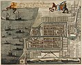
 AMH-4596-NA View of the castle and city of Batavia.jpg 2,400 × 1,806; 951 KB
-
 Plan de la ville et du château de Batavia.jpg 630 × 512; 140 KB
-

-
 AMH-7985-KB Bird's eye view map of the siege of Batavia in 1629.jpg 2,400 × 1,841; 1.12 MB
-
 AMH-4595-NA Map of Batavia and environs.jpg 2,400 × 1,997; 535 KB
-
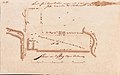
 AMH-4579-NA Map of Fort De Zevenhoek.jpg 2,400 × 1,662; 501 KB
-
 AMH-4594-NA Map of Batavia.jpg 2,400 × 1,709; 605 KB
-

-

-

-

-
 AMH-4576-NA Map of the water fort at Batavia.jpg 2,400 × 1,123; 263 KB
-
 AMH-6036-NA Map of farmlands in the Batavia region, part six.jpg 2,400 × 1,494; 491 KB
-
 COLLECTIE TROPENMUSEUM Batavia met het Kasteel anno 1681 TMnr 5681-1.jpg 800 × 640; 203 KB
-
 Tijgersgracht in 1681.jpg 1,193 × 361; 226 KB
-
 Waere affbeeldinge wegens het casteel ende stadt Batavia (...) (BM 1875,0710.665).jpg 2,500 × 2,041; 1.38 MB
-
-
 AMH-6932-KB Map of Batavia and environs.jpg 2,400 × 1,948; 1.04 MB
-

-
 AMH-5641-KB Map of Batavia and environs.jpg 2,400 × 1,941; 672 KB
-

-

-
 AMH-6031-NA Map of farmlands in the Batavia region, part one.jpg 2,400 × 1,377; 378 KB
-
 AMH-6033-NA Map of farmlands in the Batavia region, part three.jpg 2,400 × 1,492; 488 KB
-
 AMH-6034-NA Map of farmlands in the Batavia region, part four.jpg 2,400 × 1,509; 490 KB
-
 AMH-6045-NA Map of farmlands in the Batavia area, part ten.jpg 2,400 × 1,488; 519 KB
-
 AMH-6057-NA Map of farmlands in the Batavia area, part twenty five.jpg 2,400 × 1,510; 419 KB
-
 AMH-6032-NA Map of farmlands in the Batavia region, part two.jpg 2,400 × 1,456; 461 KB
-
 AMH-6046-NA Map of farmlands in the Batavia area, part twelve.jpg 2,400 × 1,517; 529 KB
-
 AMH-6047-NA Map of farmlands in the Batavia area, part thirteen.jpg 2,400 × 1,542; 503 KB
-
 AMH-6048-NA Map of farmlands in the Batavia area, part fourteen.jpg 2,400 × 1,490; 499 KB
-
 AMH-6049-NA Map of farmlands in the Batavia area, part fifteen.jpg 2,400 × 1,523; 486 KB
-
 AMH-6050-NA Map of farmlands in the Batavia area, part sixteen.jpg 2,400 × 1,529; 473 KB
-
 AMH-6051-NA Map of farmlands in the Batavia area, part seventeen.jpg 2,400 × 1,521; 452 KB
-
 AMH-6052-NA Map of farmlands in the Batavia area, part eighteen.jpg 1,499 × 2,400; 429 KB
-
 AMH-6053-NA Map of farmlands in the Batavia area, part nineteen.jpg 2,400 × 1,453; 392 KB
-
 AMH-6054-NA Map of farmlands in the Batavia area, part twenty two.jpg 2,400 × 1,508; 399 KB
-
 AMH-6055-NA Map of farmlands in the Batavia area, part twenty three.jpg 2,400 × 1,517; 422 KB
-
 AMH-6056-NA Map of farmlands in the Batavia area, part twenty four.jpg 2,400 × 1,509; 442 KB
-
 AMH-6058-NA Map of farmlands in the Batavia area, part twenty seven.jpg 2,400 × 1,528; 437 KB
-
 AMH-6059-NA Map of farmlands in the Batavia area, part twenty eight.jpg 1,582 × 2,400; 403 KB
-
 AMH-4636-NA Map of the buildings at the equipage yard in Batavia.jpg 2,400 × 1,691; 465 KB
-
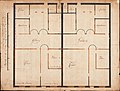 AMH-5463-NA Plans for two dwellings for the senior merchants at Castle Batavia.jpg 2,400 × 1,820; 476 KB
-

-
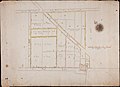 AMH-5431-NA The little fort of Jaccatra and lands bought up by the Company.jpg 2,400 × 1,738; 402 KB
-
 AMH-6035-NA Map of farmlands in the Batavia region, part five.jpg 2,400 × 1,458; 453 KB
-
 AMH-6042-NA Map of farmlands in the Batavia area, part seven.jpg 2,400 × 1,500; 490 KB
-
 AMH-6043-NA Map of farmlands in the Batavia area, part eight.jpg 2,400 × 1,523; 487 KB
-
 AMH-6044-NA Map of farmlands in the Batavia area, part nine.jpg 2,400 × 1,481; 469 KB


.jpg)


_(BM_1875,0710.665).jpg)


.jpeg)


.jpg)


