Category:17th-century maps of Istria
Media in category "17th-century maps of Istria"
The following 24 files are in this category, out of 24 total.
-
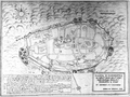
 Map of Trieste 1600.jpg 800 × 600; 156 KB
-
 Pregledni zemljevid Istre leta 1604.jpg 4,764 × 6,802; 4.32 MB
-
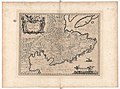
 Map of Slavonia, Croatia, Carnia, Istria, and Bosnia by Abraham Ortelius.jpeg 1,597 × 1,188; 540 KB
-

-
 Istria - Porcacchi Tomaso - 1620.jpg 1,500 × 1,258; 1.6 MB
-
 Krain BV044698768.jpg 8,491 × 6,585; 9 MB
-
 Krain BV044705086.jpg 8,801 × 6,851; 9.55 MB
-
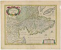
 Atlas Van der Hagen-KW1049B12 071-ISTRIA olim IAPIDIA.jpeg 5,500 × 4,272; 2.95 MB
-
 Blaeu 1645 - Karstia Carniola Histria et Windorum Marchia.jpg 3,652 × 3,051; 1.37 MB
-
 Italia - di Matteo Greuter... - btv1b525056959 (03 of 24).jpg 10,152 × 7,628; 9.93 MB
-
 "Istria olim Lapidia" (22264851431).jpg 3,948 × 3,102; 2.4 MB
-
 Joan Blaeu, Atlas Maior - Venedig.png 700 × 600; 675 KB
-
 Istria olim Japidia - btv1b532140047 (2 of 3).jpg 6,120 × 4,768; 6.39 MB
-
 Atlante Veneto Volume 2 049.jpg 10,281 × 7,117; 8.73 MB
-
 Istria olim Iapidia - btv1b53042256n (1 of 2).jpg 7,855 × 6,061; 7.35 MB
-
 Istria olim Iapidia - btv1b530425772 (1 of 2).jpg 6,102 × 4,729; 5.71 MB
-
 Giacomo Fino - Pianta di Capodistria (1619).png 961 × 719; 963 KB
-
 Istria olim Iapidia - btv1b531702978 (2 of 3).jpg 8,743 × 6,461; 9.48 MB
-
 Istria olim Iapidia 1640.jpg 3,248 × 2,760; 7.09 MB
-
 Istria olim Lapidia - CBT 5881817.jpg 5,623 × 4,427; 7.27 MB
-
 Istria olim Lapidia 1633.jpg 14,091 × 12,018; 20.12 MB
-
 Istria olim Lapidia 1642.jpg 6,828 × 5,739; 5.23 MB
-
 Joan Blaeu - L'Istrie (17. stoletje).jpg 2,456 × 1,860; 3.67 MB
-
 Johannes Janssonius - zemljevid Istre (17. stoletje).jpg 2,000 × 1,647; 1.27 MB


.jpg)
.jpg)

.jpg)

.jpg)
.jpg)
.png)
.jpg)


.jpg)
.jpg)