Category:1810 maps of the United Kingdom
Media in category "1810 maps of the United Kingdom"
The following 9 files are in this category, out of 9 total.
-

-

-
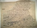
 Londres en 1810.png 5,130 × 3,075; 1.86 MB
-
 Ordnance Survey Drawings - Bedminster (OSD 48).jpg 4,000 × 3,089; 4.45 MB
-
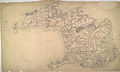
 Ordnance Survey Drawings - Cardigan, Cardigan (Sir Ceredigeon) (OSD 185).jpg 4,000 × 3,062; 5.02 MB
-
 Ordnance Survey Drawings - Chiddingfold (OSD 86).jpg 4,000 × 2,701; 4.61 MB
-
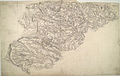
 Ordnance Survey Drawings - Haverfordwest, Pembrokeshire (Sir Benfro) (OSD 183).jpg 4,000 × 2,404; 2.6 MB
-
 Ordnance Survey Drawings - Luton (OSD 148).jpg 4,000 × 2,534; 3.24 MB
-
 Ordnance Survey Drawings - Ockley (OSD 90).jpg 4,000 × 3,969; 7.07 MB


.jpg)
_(OSD_185).jpg)
.jpg)
_(OSD_183).jpg)
.jpg)
.jpg)