Category:1820 maps of Massachusetts
Subcategories
This category has only the following subcategory.
1
Media in category "1820 maps of Massachusetts"
The following 7 files are in this category, out of 7 total.
-
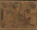 Map of Boston and its vicinity from actual survey (2674751621).jpg 2,000 × 1,659; 3.09 MB
-
 Map of Boston and its vicinity LOC 76692110.jpg 9,550 × 7,858; 11.25 MB
-
 Map of Boston and its vicinity LOC 76692110.tif 9,550 × 7,858; 214.7 MB
-
-
 Market Street, Lynn, Mass., as it appeared in 1820. LOC 75694587.jpg 5,184 × 2,256; 1.48 MB
-
 Market Street, Lynn, Mass., as it appeared in 1820. LOC 75694587.tif 5,184 × 2,256; 33.46 MB
-
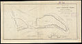
 Natural and political history of the Gerry-mander! (6094165372).jpg 1,618 × 2,000; 3.06 MB
.jpg)

.jpg)

.jpg)