Category:1838 maps of Hawaii
Media in category "1838 maps of Hawaii"
The following 4 files are in this category, out of 4 total.
-
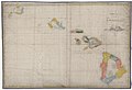
 A map of the Hawaiian Islands. LOC 2003627048.jpg 6,385 × 5,202; 4.59 MB
-
 A map of the Hawaiian Islands. LOC 2003627048.tif 6,385 × 5,202; 95.03 MB
-
 Map of the Hawaiian Islands according to the latest surveys - btv1b53102770q.jpg 13,209 × 8,983; 17.95 MB
-
 Niihau 1838 map by Kalama.jpg 520 × 516; 151 KB


