Category:1840s maps of Arkansas
States of the United States: Alabama · Alaska · Arkansas · California · Connecticut · Delaware · Florida · Georgia · Hawaii · Idaho · Illinois · Indiana · Iowa · Kentucky · Louisiana · Maine · Maryland · Massachusetts · Michigan · Minnesota · Mississippi · Missouri · Montana · Nebraska · New Hampshire · New Mexico · New York · North Dakota · Ohio · Oklahoma · Oregon · Pennsylvania · Rhode Island · South Carolina · South Dakota · Tennessee · Texas · Utah · Vermont · Virginia · Washington · Wisconsin · Wyoming – Washington, D.C.
Puerto Rico
Puerto Rico
Media in category "1840s maps of Arkansas"
The following 2 files are in this category, out of 2 total.
-
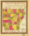
 A new map of Arkansas with its canals, roads & distances. LOC gm72003746.jpg 7,463 × 9,239; 9.37 MB
-
 A new map of Arkansas with its canals, roads & distances. LOC gm72003746.tif 7,463 × 9,239; 197.27 MB
