Category:1850s maps of Palestine
Countries of Asia: Afghanistan · Armenia‡ · Azerbaijan‡ · People's Republic of China · Cyprus‡ · Egypt‡ · Georgia‡ · India · Indonesia‡ · Iran · Iraq · Japan · Jordan · Lebanon · Pakistan · Philippines · Russia‡ · Syria · Turkey‡
Limited recognition: Abkhazia‡ · Taiwan · State of Palestine
‡: partly located in Asia
Limited recognition: Abkhazia‡ · Taiwan · State of Palestine
‡: partly located in Asia
Subcategories
This category has the following 2 subcategories, out of 2 total.
J
- 1850s maps of Jerusalem (22 F)
Media in category "1850s maps of Palestine"
The following 42 files are in this category, out of 42 total.
-

-

-
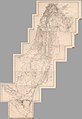 1850 Atlas von Palaestina und der Sinai Halbinsel (composite of 15 sectional sheets).jpg 22,313 × 32,413; 53.78 MB
-
 1850 Mitchell - Mitchell Map of Turkey in Asia - Geographicus - TurkeyAsia-m-50.jpg 4,000 × 3,278; 3.18 MB
-

-
 10 of '(A History of the Romans under the Empire.)' (11037870753).jpg 1,427 × 2,461; 644 KB
-
 Persia, Arabia, etc - 1852.png 1,310 × 1,024; 2.42 MB
-
 HEINZELMANN(1854) 13.531 Kartenblatt Palästina.jpg 2,443 × 2,963; 3.55 MB
-

-

-
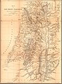
 TOBIN(1855) p189 PALESTINE.jpg 2,635 × 3,621; 3.79 MB
-
 1856 Kiepert Map of Lebanon - Geographicus - Lebanon-kiepert-1856.jpg 3,000 × 3,675; 2.45 MB
-
 1856 Kiepert Map of the Sinai Peninsula, Egypt - Geographicus - Sinai-kiepert-1856.jpg 3,500 × 4,449; 4.12 MB
-
 Arthur Penrhyn Stanley, Palestine (FL39908254 2507904).jpg 4,652 × 6,731; 43.85 MB
-

-
 KiepertSouthernPalestine1856.jpg 4,522 × 6,119; 12.29 MB
-
 Arthur Penrhyn Stanley, Palestine (FL6878618 2370062).jpg 2,200 × 2,864; 2.94 MB
-
 Arthur Penrhyn Stanley, South of Palestine (FL6879593 2369426).jpg 2,947 × 2,100; 2.76 MB
-

-
 Grimm, J.L. Mahlmann, H. Tiberias. 1850-2.jpg 7,771 × 5,661; 8.84 MB
-
 Index Map and Sectional Title Page, Atlas of Palestine and the Sinai Peninsula (cropped).jpg 7,766 × 7,194; 5.04 MB
-
 Index Map and Sectional Title Page, Atlas of Palestine and the Sinai Peninsula.jpg 11,712 × 8,483; 10.62 MB
-

-
-
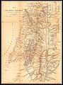
 Modern Palestine, Illustrated atlas, and modern history of the World, 1851.jpg 3,750 × 4,700; 16.01 MB
-
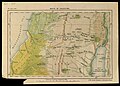
 Palestine or Canaan (3855704259).jpg 1,548 × 2,000; 2.84 MB
-
 Phebe Ellen Nichols. Map of Palestine or Canaan. 1853.jpg 5,040 × 6,515; 11.28 MB
-
 Sect. I. Beirut. Atlas of Palestine and the Sinai Peninsula.jpg 11,712 × 8,483; 16.03 MB
-
 Sect. II. Damascus. Atlas of Palestine and the Sinai Peninsula.jpg 11,712 × 8,483; 11.81 MB
-
 Sect. III. Tiberias. Atlas of Palestine and the Sinai Peninsula.jpg 11,712 × 8,483; 15.01 MB
-
 Sect. IV. El Mezareib. Atlas of Palestine and the Sinai Peninsula.jpg 11,648 × 8,483; 13.61 MB
-
 Sect. IX. Mayha. Atlas of Palestine and the Sinai Peninsula.jpg 11,696 × 8,483; 11.81 MB
-
 Sect. V. Jerusalem. Atlas of Palestine and the Sinai Peninsula.jpg 11,712 × 8,483; 14.95 MB
-
 Sect. VI. Kulat Zerka. Atlas of Palestine and the Sinai Peninsula.jpg 11,712 × 8,483; 12.12 MB
-
 Sect. VII. El Khulil (Hebron). Atlas of Palestine and the Sinai Peninsula.jpg 11,576 × 8,483; 12.79 MB
-
 Sect. VIII. Todtes Meer. Atlas of Palestine and the Sinai Peninsula.jpg 11,664 × 8,483; 12.7 MB
-
 Sect. X. Petra. Atlas of Palestine and the Sinai Peninsula.jpg 11,680 × 8,483; 12.5 MB
-
 Sect. XI. Pfuhl. Atlas of Palestine and the Sinai Peninsula.jpg 11,672 × 8,483; 11.99 MB
-
 Sect. XII. Akabah. Atlas of Palestine and the Sinai Peninsula.jpg 11,672 × 8,483; 12.63 MB
-
 Sect. XIII. Menetfah. Atlas of Palestine and the Sinai Peninsula.jpg 11,640 × 8,483; 12.53 MB
-
 Sect. XIV. Abu Suiveirah. Atlas of Palestine and the Sinai Peninsula.jpg 11,584 × 8,483; 12.47 MB
-

.jpg)

.jpg)

%27_(11040448834).jpg)
%27_(11037870753).jpg)

_13.531_Kartenblatt_Pal%C3%A4stina.jpg)
.jpg)
.jpg)
_p189_PALESTINE.jpg)


.jpg)
.jpg)

.jpg)
.jpg)


.jpg)


.jpg)


._Atlas_of_Palestine_and_the_Sinai_Peninsula.jpg)


).jpg)