Category:1852 U.S. presidential election maps by state
Media in category "1852 U.S. presidential election maps by state"
The following 24 files are in this category, out of 24 total.
-
 Alabama Presidential Election Results 1852.svg 800 × 1,254; 700 KB
-
 Arkansas Presidential Election Results 1852.svg 759 × 665; 694 KB
-
 California Presidential Election Results 1852.png 1,497 × 1,816; 246 KB
-
 California Presidential Election Results 1852.svg 2,485 × 3,000; 317 KB
-
 Connecticut Presidential Election Results 1852.svg 810 × 595; 30 KB
-
 Florida Presidential Election Results 1852.svg 800 × 769; 1.8 MB
-
 Illinois Presidential Election Results 1852.svg 810 × 810; 565 KB
-
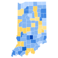 Indiana Presidential Election Results 1852.svg 744 × 744; 209 KB
-
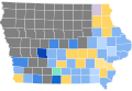 Iowa Presidential Election Results 1852.svg 800 × 551; 367 KB
-
 Kentucky Presidential Election Results 1852.svg 744 × 341; 570 KB
-
 Maryland Presidential Election Results 1852.svg 800 × 420; 1.07 MB
-
 Massachusetts Presidential Election Results 1852.svg 810 × 502; 27 KB
-
 Michigan Presidential Election Results 1852.svg 800 × 937; 1.31 MB
-
 New Hampshire Presidential Election Results 1852.svg 810 × 810; 7 KB
-
 New Jersey Presidential Election Results 1852.svg 810 × 810; 31 KB
-
 New York Presidential Election Results 1852.svg 800 × 600; 2.06 MB
-
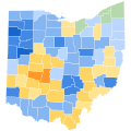 Ohio Presidential Election Results 1852.svg 810 × 810; 40 KB
-
 Pennsylvania Presidential Election Results 1852.svg 800 × 461; 716 KB
-
 Rhode Island Presidential Election Results 1852.svg 810 × 810; 13 KB
-
 Tennessee Presidential Election Results 1852.svg 514 × 137; 95 KB
-
 Texas Presidential Election Results 1852.svg 800 × 759; 3.45 MB
-
 Vermont Presidential Election Results 1852.svg 810 × 810; 18 KB
-
 Virginia Presidential Election Results 1852.svg 331 × 213; 155 KB
-
 Wisconsin Presidential Election Results 1852.svg 245 × 262; 44 KB


