Category:1855 maps of Europe
Temperate regions: North America · South America · Africa · Europe · Asia · – Polar regions: – Other regions:
English: 1855 maps of Europe
Español: Mapas de Europa en 1855
Suomi: Euroopan kartat vuodelta 1855
Română: Hărți ale Europei din 1855
Subcategories
This category has the following 13 subcategories, out of 13 total.
.
F
G
- 1855 maps of Greece (2 F)
I
N
- 1855 maps of Norway (7 F)
R
- 1855 maps of Russia (4 F)
S
- 1855 maps of Spain (3 F)
- 1855 maps of Switzerland (1 F)
U
- 1855 maps of Ukraine (23 F)
Media in category "1855 maps of Europe"
The following 12 files are in this category, out of 12 total.
-
 158 of 'Summer Tours in Central Europe. 1853-54' (11045605013).jpg 2,624 × 1,967; 1.1 MB
-
 16 of 'Summer Tours in Central Europe. 1853-54' (11047260696).jpg 2,595 × 1,982; 1.13 MB
-
 164 of 'The Illustrated History of the War against Russia. Plates' (11047069545).jpg 1,837 × 2,766; 1.19 MB
-
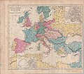
 1855 Colton Map of Europe - Geographicus - Europe-colton-1855.jpg 3,500 × 2,917; 3.28 MB
-
 1855 map - Carte du Théâtre de la Guerre.jpg 10,800 × 7,500; 24.31 MB
-
-
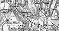 Bussigny 1855.jpg 1,211 × 648; 547 KB
-
 Carte générale d'Europe dressée - par Charle... - btv1b53093083p.jpg 9,384 × 6,712; 10.72 MB
-
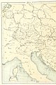
 Central and Southern Europe Map 1855.jpg 5,844 × 5,102; 3.12 MB
-
 Heinrich Berghaus. Europe, Ethnographic, 1855.jpg 851 × 649; 134 KB
-
 Map of the Countries Between England & India, 3902002.jpg 22,704 × 15,902; 101.29 MB
-
 Panorama Van Het Tooneel Des Oorlogs In Het Noorden Van Europa.jpg 16,162 × 11,757; 59.51 MB
.jpg)
.jpg)
.jpg)


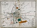
_-_Plan_de_la_ville_de_Rennes_avec_indication_des_travaux_ex%C3%A9cut%C3%A9s_depuis_1855_(A._C._Rennes,_1_Fi_76)._HR.jpg)


