Category:1855 maps of India
Countries of Asia: People's Republic of China · India · Japan · Russia‡ · Turkey‡
‡: partly located in Asia
‡: partly located in Asia
| 1850 1851 1852 1853 1854 1855 1857 1858 1859 → |
English: 1855 maps made in India or from India or showing history of India
Media in category "1855 maps of India"
The following 8 files are in this category, out of 8 total.
-
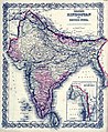
 1855 Colton Map of India - Geographicus - India-colton-1855.jpg 2,919 × 3,500; 2.96 MB
-

-

-
 Ahmedabad 1855.jpg 2,325 × 1,585; 917 KB
-
 Britishindia1855.jpg 504 × 614; 343 KB
-
 Map of the native town of Bombay, completed to 1855. LOC 2015588078.jpg 12,629 × 10,696; 15.63 MB
-
 Map of the native town of Bombay, completed to 1855. LOC 2015588078.tif 12,629 × 10,696; 386.47 MB
-
 Map of Tibet in 1855 from Vorder-Indien oder das Indo-Britische Reich (cropped).jpg 3,475 × 1,630; 2.64 MB

.jpg)
.jpg)


.jpg)