Category:1860 maps of Louisiana
States of the United States: California · Delaware · Florida · Illinois · Iowa · Kansas · Louisiana · Maryland · Massachusetts · Michigan · New Jersey · New Mexico · New York · Ohio · Pennsylvania · Utah · Virginia – Washington, D.C.
| 1860 1861 1862 1863 1864 1865 1866 |
Media in category "1860 maps of Louisiana"
The following 24 files are in this category, out of 24 total.
-
 (Shreveport, Louisiana, and vicinity). LOC 86691332.jpg 4,768 × 4,842; 2.11 MB
-
 (Shreveport, Louisiana, and vicinity). LOC 86691332.tif 4,768 × 4,842; 66.05 MB
-
 Le Tour du monde-01-p187.jpg 514 × 746; 75 KB
-

-

-

-

-
 Map of the Parish of Caldwell, Louisiana - from United States surveys. LOC 2012592314.jpg 11,908 × 8,572; 9.37 MB
-
 Map of the Parish of Caldwell, Louisiana - from United States surveys. LOC 2012592314.tif 11,908 × 8,572; 292.04 MB
-
 Map of the Parish of Carroll, Louisiana - from the United States surveys. LOC 2012592309.jpg 9,459 × 12,366; 11.95 MB
-
 Map of the Parish of Carroll, Louisiana - from the United States surveys. LOC 2012592309.tif 9,459 × 12,366; 334.65 MB
-
 Map of the Parish of Catahoula, Louisiana - from United States surveys. LOC 2012592312.jpg 12,394 × 13,575; 17.27 MB
-
 Map of the Parish of Concordia, Louisiana - from United States surveys. LOC 2012592310.jpg 9,464 × 12,555; 11.75 MB
-
 Map of the Parish of Concordia, Louisiana - from United States surveys. LOC 2012592310.tif 9,464 × 12,555; 339.95 MB
-
 Map of the Parish of Franklin, Louisiana - from the United States surveys. LOC 2012592307.jpg 9,499 × 12,609; 11.74 MB
-
 Map of the Parish of Franklin, Louisiana - from the United States surveys. LOC 2012592307.tif 9,499 × 12,609; 342.67 MB
-
 Map of the Parish of Madison, La. - from United States surveys. LOC 2012592302.jpg 12,354 × 9,541; 13.03 MB
-
 Map of the Parish of Madison, La. - from United States surveys. LOC 2012592302.tif 12,354 × 9,541; 337.23 MB
-
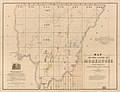 Map of the Parish of Morehouse, Louisiana - from United States surveys. LOC 2012592303.jpg 12,505 × 9,537; 12.51 MB
-
 Map of the Parish of Tensas, Louisiana - from United States Surveys. LOC 2012592301.jpg 9,405 × 12,706; 10.3 MB
-
 Map of the Parish of Tensas, Louisiana - from United States Surveys. LOC 2012592301.tif 9,405 × 12,706; 341.89 MB
-
 Map of the Parish of Washita, Louisiana - from United States Surveys. LOC 2012592321.jpg 12,579 × 9,567; 12.41 MB
-
 Map of the Parish of Washita, Louisiana - from United States Surveys. LOC 2012592321.tif 12,579 × 9,567; 344.31 MB
-

._LOC_86691332.jpg)


