Category:1872 U.S. presidential election maps, county subdivisions
Media in category "1872 U.S. presidential election maps, county subdivisions"
The following 12 files are in this category, out of 12 total.
-
 PresidentialCounty1872Colorbrewer.gif 2,800 × 1,700; 200 KB
-

-
 1872 United States presidential election results map by county.svg 555 × 352; 1.11 MB
-
 CartogramLiberalRepublicanPresidentialCounty1872Colorbrewer.gif 2,800 × 1,700; 195 KB
-
 CartogramOtherPresidentialCounty1872Colorbrewer.gif 2,800 × 1,700; 170 KB
-
 CartogramPresidentialCounty1872Colorbrewer.png 2,800 × 1,700; 307 KB
-
 CartogramRepublicanPresidentialCounty1872Colorbrewer.gif 2,800 × 1,700; 199 KB
-
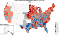
 LiberalRepublicanPresidentialCounty1872.gif 2,800 × 2,200; 234 KB
-
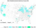 OtherPresidentialCounty1872.gif 2,800 × 2,200; 182 KB
-
 PresidentialCounty1872.gif 2,800 × 2,200; 261 KB
-
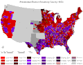
 RepublicanPresidentialCounty1872.gif 2,800 × 2,200; 237 KB
-
 Vote for Republican President Ulysses S Grant 1872.gif 558 × 508; 111 KB


