Category:1878 maps of Illinois
States of the United States: California · Colorado · Connecticut · Illinois · Maine · Maryland · Massachusetts · Michigan · New Hampshire · New York · Pennsylvania · Texas · Vermont
| ← 1870 1871 1872 1873 1874 1875 1876 1877 1878 1879 |
Media in category "1878 maps of Illinois"
The following 6 files are in this category, out of 6 total.
-
 1878 Travelers and shippers railway guide map of Chicago.jpg 6,828 × 8,845; 16.56 MB
-
 Decatur, Ill. (2673835549).jpg 2,000 × 1,560; 2.97 MB
-
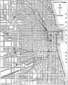 EB9 Chicago.jpg 1,243 × 1,537; 455 KB
-
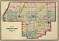 Past and Present of Woodford County Illinois 1878 county map.jpg 2,575 × 1,812; 1.41 MB
-

-
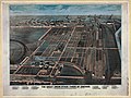 Union stock yards chicago 1870s loc.jpg 8,662 × 6,477; 11.79 MB

.jpg)


_(14587390789).jpg)
