Category:1880 maps of Wisconsin
States of the United States: California · Louisiana · Massachusetts · Michigan · Missouri · New Jersey · New York · Ohio · Oregon · Texas · Vermont · Washington · Wisconsin · Wyoming – Washington, D.C.
| 1880 1883 1884 1885 1886 1887 1888 1889 → |
Media in category "1880 maps of Wisconsin"
The following 4 files are in this category, out of 4 total.
-
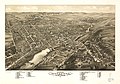
 Bird's eye view of River Falls, Pierce County, Wisconsin, 1880. LOC 96680539.jpg 6,113 × 4,420; 7.14 MB
-
 Bird's eye view of River Falls, Pierce County, Wisconsin, 1880. LOC 96680539.tif 6,113 × 4,420; 77.3 MB
-
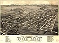
 Bird's eye view of Waukesha, c.s. of Waukesha Co., Wis. 1880. LOC 75696726.jpg 8,400 × 5,856; 13.52 MB
-
 Milwaukee Sewerage Map 1880.jpg 1,305 × 1,526; 468 KB


