Category:1888 maps of Boston
Subcategories
This category has only the following subcategory.
Media in category "1888 maps of Boston"
The following 91 files are in this category, out of 91 total.
-
 1888 Boston map showing proposed NY&B Rapid Transit route.jpg 8,672 × 10,761; 19.97 MB
-
 1888 West End Street Railway map.png 2,820 × 3,500; 10.08 MB
-
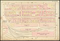
 Atlas of the city of Boston - city proper - plate 1 (19835333806).jpg 2,000 × 1,364; 2.73 MB
-
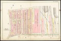
 Atlas of the city of Boston - city proper - plate 10 (19835336926).jpg 2,000 × 1,373; 2.77 MB
-
 Atlas of the city of Boston - city proper - plate 11 (19240626843).jpg 2,000 × 1,363; 2.45 MB
-
 Atlas of the city of Boston - city proper - plate 12 (19835338156).jpg 2,000 × 1,362; 2.71 MB
-
 Atlas of the city of Boston - city proper - plate 13 (19673510288).jpg 2,000 × 1,365; 2.63 MB
-
 Atlas of the city of Boston - city proper - plate 14 (19673528580).jpg 2,000 × 1,364; 2.82 MB
-
 Atlas of the city of Boston - city proper - plate 15 (19861555765).jpg 2,000 × 1,363; 2.84 MB
-
 Atlas of the city of Boston - city proper - plate 16 (19866501501).jpg 2,000 × 1,362; 2.66 MB
-
 Atlas of the city of Boston - city proper - plate 17 (19674951509).jpg 2,000 × 1,376; 2.52 MB
-
 Atlas of the city of Boston - city proper - plate 18 (19854137472).jpg 2,000 × 1,368; 2.98 MB
-
 Atlas of the city of Boston - city proper - plate 19 (19674952139).jpg 2,000 × 1,369; 2.72 MB
-
 Atlas of the city of Boston - city proper - plate 2 (19673523550).jpg 2,000 × 1,358; 2.7 MB
-
 Atlas of the city of Boston - city proper - plate 20 (19674952359).jpg 2,000 × 1,365; 2.54 MB
-
 Atlas of the city of Boston - city proper - plate 21 (19673531210).jpg 2,000 × 1,367; 2.69 MB
-
 Atlas of the city of Boston - city proper - plate 22 (19835342066).jpg 2,000 × 1,366; 2.56 MB
-
 Atlas of the city of Boston - city proper - plate 23 (19861559015).jpg 2,000 × 1,367; 2.57 MB
-
 Atlas of the city of Boston - city proper - plate 24 (19866505301).jpg 2,000 × 1,356; 2.43 MB
-
 Atlas of the city of Boston - city proper - plate 25 (19861561525).jpg 2,000 × 1,365; 2.58 MB
-
 Atlas of the city of Boston - city proper - plate 26 (19835344966).jpg 2,000 × 1,353; 2.4 MB
-
 Atlas of the city of Boston - city proper - plate 27 (19861562255).jpg 2,000 × 1,362; 2.68 MB
-
 Atlas of the city of Boston - city proper - plate 28 (19673535710).jpg 2,000 × 1,360; 2.78 MB
-
 Atlas of the city of Boston - city proper - plate 29 (19673536090).jpg 2,000 × 1,367; 2.9 MB
-
 Atlas of the city of Boston - city proper - plate 3 (19673523900).jpg 2,000 × 1,360; 2.89 MB
-
 Atlas of the city of Boston - city proper - plate 30 (19238896354).jpg 2,000 × 1,361; 2.81 MB
-
 Atlas of the city of Boston - city proper - plate 31 (19238896574).jpg 2,000 × 1,368; 2.66 MB
-
 Atlas of the city of Boston - city proper - plate 32 (19835347286).jpg 2,000 × 1,364; 1.96 MB
-
 Atlas of the city of Boston - city proper - plate 33 (19855456892).jpg 2,000 × 1,377; 2.56 MB
-
 Atlas of the city of Boston - city proper - plate 34 (19836654196).jpg 2,000 × 1,369; 2.43 MB
-
 Atlas of the city of Boston - city proper - plate 35 (19867817301).jpg 2,000 × 1,376; 2.35 MB
-
 Atlas of the city of Boston - city proper - plate 36 (19241955873).jpg 2,000 × 1,372; 2.47 MB
-
 Atlas of the city of Boston - city proper - plate 37 (19674847560).jpg 2,000 × 1,371; 2.49 MB
-
 Atlas of the city of Boston - city proper - plate 38 (19241956413).jpg 2,000 × 1,367; 2.28 MB
-
 Atlas of the city of Boston - city proper - plate 39 (19862870425).jpg 2,000 × 1,374; 2.33 MB
-
 Atlas of the city of Boston - city proper - plate 4 (19673506558).jpg 2,000 × 1,354; 2.78 MB
-
 Atlas of the city of Boston - city proper - plate 40 (19674829948).jpg 2,000 × 1,365; 2.3 MB
-
 Atlas of the city of Boston - city proper - plate 41 (19855459702).jpg 2,000 × 1,368; 2.33 MB
-
 Atlas of the city of Boston - city proper - plate 42 (19862871715).jpg 2,000 × 1,370; 2.36 MB
-
 Atlas of the city of Boston - city proper - plate 43 (19241958493).jpg 2,000 × 1,369; 2.25 MB
-
 Atlas of the city of Boston - city proper - plate 44 (19836657566).jpg 2,000 × 1,383; 2.34 MB
-
 Atlas of the city of Boston - city proper - plate 45 (19674850460).jpg 2,000 × 1,373; 2.44 MB
-
 Atlas of the city of Boston - city proper - plate 46 (19674832068).jpg 2,000 × 1,371; 2.59 MB
-
 Atlas of the city of Boston - city proper - plate 47 (19836658436).jpg 2,000 × 1,373; 2.61 MB
-
 Atlas of the city of Boston - city proper - plate 48 (19241959963).jpg 2,000 × 1,367; 2.73 MB
-
 Atlas of the city of Boston - city proper - plate 49 (19855462092).jpg 2,000 × 1,371; 3.01 MB
-
 Atlas of the city of Boston - city proper - plate 5 (19238884714).jpg 2,000 × 1,361; 2.29 MB
-
 Atlas of the city of Boston - city proper - plate 50 (19676269509).jpg 2,000 × 1,369; 2.99 MB
-
 Atlas of the city of Boston - city proper - plate 51 (19862874295).jpg 2,000 × 1,377; 2.84 MB
-
 Atlas of the city of Boston - city proper - plate 52 (19836659986).jpg 2,000 × 1,367; 2.44 MB
-
 Atlas of the city of Boston - city proper - plate 53 (19867823101).jpg 2,000 × 1,369; 2.84 MB
-
 Atlas of the city of Boston - city proper - plate 54 (19836661086).jpg 2,000 × 1,371; 2.92 MB
-
 Atlas of the city of Boston - city proper - plate 55 (19240216904).jpg 2,000 × 1,372; 2.89 MB
-
 Atlas of the city of Boston - city proper - plate 56 (19674854230).jpg 2,000 × 1,379; 2.64 MB
-
 Atlas of the city of Boston - city proper - plate 57 (19674835738).jpg 2,000 × 1,365; 2.38 MB
-
 Atlas of the city of Boston - city proper - plate 58 (19867825111).jpg 2,000 × 1,376; 2.52 MB
-
 Atlas of the city of Boston - city proper - plate 59 (19862877155).jpg 2,000 × 1,370; 2.74 MB
-
 Atlas of the city of Boston - city proper - plate 6 (19674946919).jpg 2,000 × 1,364; 3.03 MB
-
 Atlas of the city of Boston - city proper - plate 60 (19867825681).jpg 2,000 × 1,374; 2.7 MB
-
 Atlas of the city of Boston - city proper - plate 61 (19836663006).jpg 2,000 × 1,367; 2.71 MB
-
 Atlas of the city of Boston - city proper - plate 62 (19855466342).jpg 2,000 × 1,370; 2.77 MB
-
 Atlas of the city of Boston - city proper - plate 63 (19855466592).jpg 2,000 × 1,366; 2.64 MB
-
 Atlas of the city of Boston - city proper - plate 64 (19855467382).jpg 2,000 × 1,369; 2.81 MB
-
 Atlas of the city of Boston - city proper - plate 65 (19867827921).jpg 2,000 × 1,365; 2.7 MB
-
 Atlas of the city of Boston - city proper - plate 66 (19867828171).jpg 2,000 × 1,363; 2.66 MB
-
 Atlas of the city of Boston - city proper - plate 67 (19676276009).jpg 2,000 × 1,366; 2.14 MB
-
 Atlas of the city of Boston - city proper - plate 68 (19855469042).jpg 2,000 × 1,367; 2.39 MB
-
 Atlas of the city of Boston - city proper - plate 69 (19241967593).jpg 2,000 × 1,367; 2.52 MB
-
 Atlas of the city of Boston - city proper - plate 7 (19238885304).jpg 2,000 × 1,368; 2.63 MB
-
 Atlas of the city of Boston - city proper - plate 70 (19867829771).jpg 2,000 × 1,366; 2.59 MB
-
 Atlas of the city of Boston - city proper - plate 71 (19867830121).jpg 2,000 × 1,363; 2.84 MB
-
 Atlas of the city of Boston - city proper - plate 72 (19867830431).jpg 2,000 × 1,366; 2.95 MB
-
 Atlas of the city of Boston - city proper - plate 73 (19674841898).jpg 2,000 × 1,370; 2.71 MB
-
 Atlas of the city of Boston - city proper - plate 74 (19674861120).jpg 1,452 × 2,000; 2.71 MB
-
 Atlas of the city of Boston - city proper - plate 8 (19238885614).jpg 2,000 × 1,366; 2.47 MB
-
 Atlas of the city of Boston - city proper - plate 9 (19673525810).jpg 2,000 × 1,361; 2.9 MB
-

-

-
 Boston 1888 Sampson ArtSquare.jpg 361 × 389; 204 KB
-
 Boston 1888 Sampson ScollaySquare area.jpg 760 × 602; 643 KB
-
 Boston 1888 SampsonMap BackBay detail.jpg 1,284 × 835; 677 KB
-
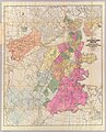
 Boston Highlands, Massachusetts. Wards 19, 20, 21 & 22 of Boston. LOC 75694562.jpg 12,112 × 9,360; 28.39 MB
-
 Boston Highlands, Massachusetts. Wards 19, 20, 21 & 22 of Boston. LOC 75694562.tif 12,112 × 9,360; 324.35 MB
-
 DoverStreet area 1888 BostonMap Sampson, Murdock & Co.jpg 1,010 × 772; 802 KB
-
 Map of Boston, 1888, published expressly for the Boston directory. LOC gm70000117.jpg 8,317 × 10,264; 13.38 MB
-
 Map of Boston, 1888, published expressly for the Boston directory. LOC gm70000117.tif 8,317 × 10,264; 244.23 MB
-
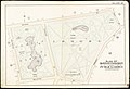
 March 1888 map and profile of old and new Stony Brook conduits.jpg 2,001 × 1,632; 693 KB
-
 Outline and index map of Boston city proper (19674945069).jpg 2,000 × 1,357; 2.96 MB
-
 Outline and index map of Boston city proper (19676263689).jpg 2,000 × 1,383; 2.98 MB
-
 Situationsplan von Boston (Massachusetts).jpg 727 × 459; 97 KB
-
 Steam railroads in Boston 1888 (7557402048).jpg 4,486 × 4,140; 19.75 MB

.jpg)
.jpg)
.jpg)
.jpg)
.jpg)
.jpg)
.jpg)
.jpg)
.jpg)
.jpg)
.jpg)
.jpg)
.jpg)
.jpg)
.jpg)
.jpg)
.jpg)
.jpg)
.jpg)
.jpg)
.jpg)
.jpg)
.jpg)
.jpg)
.jpg)
.jpg)
.jpg)
.jpg)
.jpg)
.jpg)
.jpg)
.jpg)
.jpg)
.jpg)
.jpg)
.jpg)
.jpg)
.jpg)
.jpg)
.jpg)
.jpg)
.jpg)
.jpg)
.jpg)
.jpg)
.jpg)
.jpg)
.jpg)
.jpg)
.jpg)
.jpg)
.jpg)
.jpg)
.jpg)
.jpg)
.jpg)
.jpg)
.jpg)
.jpg)
.jpg)
.jpg)
.jpg)
.jpg)
.jpg)
.jpg)
.jpg)
.jpg)
.jpg)
.jpg)
.jpg)
.jpg)
.jpg)
.jpg)
.jpg)
_(19861550015).jpg)
_(19855456052).jpg)


.jpg)
.jpg)
.jpg)
.jpg)