Category:1895 maps of Boston
Subcategories
This category has only the following subcategory.
Media in category "1895 maps of Boston"
The following 67 files are in this category, out of 67 total.
-

-
 1895 CopleySq map Boston byCCPerkins BPL 12471.png 1,058 × 739; 1.28 MB
-
 1895 DoverSt map Boston bySample BPL 12476 detail.png 1,215 × 609; 1.22 MB
-
 1895 KnightsTemplar Boston map BPL 12472.png 921 × 688; 1.05 MB
-
 1895 MCMA map Boston byCCPerkins BPL 12471.png 1,093 × 624; 1.17 MB
-
 1895 ScollaySquare Boston BPL 12913.png 754 × 461; 646 KB
-
 1895 TremontRow map Boston byCCPerkins BPL 12471.png 1,216 × 605; 1.33 MB
-
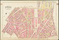
 1895 Ward 11 map detail of Atlas of the City of Boston by Bromley p9.jpg 11,442 × 7,452; 13.86 MB
-
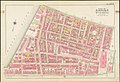
 1895-Haymarket-Square-atlas.png 2,372 × 2,449; 9.13 MB
-
 A guide to Boston (3121045758).jpg 2,000 × 1,599; 3.15 MB
-

-
 Atlas of the city of Boston, Boston proper and Roxbury - (title page) (19265078324).jpg 2,000 × 1,378; 2.33 MB
-
 Atlas of the city of Boston, Boston proper and Roxbury - plate 1 (19699722100).jpg 2,000 × 1,374; 3.16 MB
-
 Atlas of the city of Boston, Boston proper and Roxbury - plate 10 (19892738001).jpg 2,000 × 1,369; 2.95 MB
-
 Atlas of the city of Boston, Boston proper and Roxbury - plate 11 (19265082474).jpg 2,000 × 1,372; 2.85 MB
-
 Atlas of the city of Boston, Boston proper and Roxbury - plate 12 (19265082824).jpg 2,000 × 1,375; 3.04 MB
-
 Atlas of the city of Boston, Boston proper and Roxbury - plate 13 (19892738871).jpg 2,000 × 1,370; 3.06 MB
-
 Atlas of the city of Boston, Boston proper and Roxbury - plate 14 (19861505436).jpg 2,000 × 1,375; 3.16 MB
-
 Atlas of the city of Boston, Boston proper and Roxbury - plate 15 (19265084284).jpg 2,000 × 1,372; 2.93 MB
-
 Atlas of the city of Boston, Boston proper and Roxbury - plate 16 (19880262562).jpg 2,000 × 1,371; 2.97 MB
-
 Atlas of the city of Boston, Boston proper and Roxbury - plate 17 (19699708268).jpg 2,000 × 1,378; 2.92 MB
-
 Atlas of the city of Boston, Boston proper and Roxbury - plate 18 (19699728170).jpg 2,000 × 1,374; 3.02 MB
-
 Atlas of the city of Boston, Boston proper and Roxbury - plate 19 (19699728420).jpg 2,000 × 1,372; 2.94 MB
-
 Atlas of the city of Boston, Boston proper and Roxbury - plate 2 (19699722470).jpg 2,000 × 1,371; 3.08 MB
-
 Atlas of the city of Boston, Boston proper and Roxbury - plate 20 (19880263682).jpg 2,000 × 1,374; 2.8 MB
-
 Atlas of the city of Boston, Boston proper and Roxbury - plate 21 (19892742111).jpg 2,000 × 1,373; 3.01 MB
-
 Atlas of the city of Boston, Boston proper and Roxbury - plate 22 (19701075259).jpg 2,000 × 1,374; 2.81 MB
-
 Atlas of the city of Boston, Boston proper and Roxbury - plate 23 (19699710158).jpg 2,000 × 1,379; 2.42 MB
-
 Atlas of the city of Boston, Boston proper and Roxbury - plate 24 (19892743091).jpg 2,000 × 1,379; 2.42 MB
-
 Atlas of the city of Boston, Boston proper and Roxbury - plate 25 (19892743921).jpg 2,000 × 1,371; 2.39 MB
-
 Atlas of the city of Boston, Boston proper and Roxbury - plate 26 (19265088404).jpg 2,000 × 1,370; 2.49 MB
-
 Atlas of the city of Boston, Boston proper and Roxbury - plate 27 (19880266612).jpg 2,000 × 1,377; 2.33 MB
-
 Atlas of the city of Boston, Boston proper and Roxbury - plate 28 (19699731790).jpg 2,000 × 1,372; 2.32 MB
-
 Atlas of the city of Boston, Boston proper and Roxbury - plate 29 (19699732150).jpg 2,000 × 1,378; 2.32 MB
-
 Atlas of the city of Boston, Boston proper and Roxbury - plate 3 (19701068589).jpg 2,000 × 1,377; 3.02 MB
-
 Atlas of the city of Boston, Boston proper and Roxbury - plate 30 (19880267592).jpg 2,000 × 1,373; 2.35 MB
-
 Atlas of the city of Boston, Boston proper and Roxbury - plate 31 (19265090104).jpg 2,000 × 1,371; 2.35 MB
-
 Atlas of the city of Boston, Boston proper and Roxbury - plate 32 (19265090394).jpg 2,000 × 1,370; 2.75 MB
-
 Atlas of the city of Boston, Boston proper and Roxbury - plate 33 (19699733550).jpg 2,000 × 1,377; 2.45 MB
-
 Atlas of the city of Boston, Boston proper and Roxbury - plate 34 (19701079949).jpg 2,000 × 1,371; 2.47 MB
-
 Atlas of the city of Boston, Boston proper and Roxbury - plate 35 (19699734530).jpg 2,000 × 1,372; 2.84 MB
-
 Atlas of the city of Boston, Boston proper and Roxbury - plate 36 (19861514296).jpg 2,000 × 1,377; 2.66 MB
-
 Atlas of the city of Boston, Boston proper and Roxbury - plate 37 (19699715608).jpg 2,000 × 1,372; 2.59 MB
-
 Atlas of the city of Boston, Boston proper and Roxbury - plate 38 (19266812793).jpg 2,000 × 1,377; 2.91 MB
-
 Atlas of the city of Boston, Boston proper and Roxbury - plate 39 (19266813183).jpg 2,000 × 1,375; 2.35 MB
-
 Atlas of the city of Boston, Boston proper and Roxbury - plate 4 (19892736031).jpg 2,000 × 1,365; 2.78 MB
-
 Atlas of the city of Boston, Boston proper and Roxbury - plate 40 (19861515626).jpg 2,000 × 1,375; 2.78 MB
-
 Atlas of the city of Boston, Boston proper and Roxbury - plate 41 (19880271732).jpg 2,000 × 1,372; 2.88 MB
-
 Atlas of the city of Boston, Boston proper and Roxbury - plate 42 (19699717608).jpg 2,000 × 1,382; 2.71 MB
-
 Atlas of the city of Boston, Boston proper and Roxbury - plate 43 (19887755085).jpg 2,000 × 1,374; 2.61 MB
-
 Atlas of the city of Boston, Boston proper and Roxbury - plate 44 (19266815183).jpg 2,000 × 1,376; 2.12 MB
-
 Atlas of the city of Boston, Boston proper and Roxbury - plate 45 (19892751641).jpg 2,000 × 1,371; 2.31 MB
-
 Atlas of the city of Boston, Boston proper and Roxbury - plate 5 (19880258542).jpg 2,000 × 1,370; 3.14 MB
-
 Atlas of the city of Boston, Boston proper and Roxbury - plate 6 (19699723650).jpg 2,000 × 1,374; 3.06 MB
-
 Atlas of the city of Boston, Boston proper and Roxbury - plate 7 (19265080964).jpg 2,000 × 1,373; 3.11 MB
-
 Atlas of the city of Boston, Boston proper and Roxbury - plate 8 (19861503116).jpg 2,000 × 1,388; 2.71 MB
-
 Atlas of the city of Boston, Boston proper and Roxbury - plate 9 (19880260022).jpg 2,000 × 1,380; 2.69 MB
-
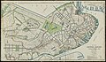
 Map of Boston (3720218991).jpg 906 × 1,024; 1.01 MB
-
 Map of Boston and vicinity (2674213545).jpg 1,311 × 2,000; 2.32 MB
-
 Map of Scollay Square and vicinity (3720670712).jpg 1,024 × 751; 498 KB
-
 Map of the city of Boston and vicinity (3721032396).jpg 910 × 1,024; 843 KB
-
 Outline and index map of Boston proper and Roxbury (19701067609).jpg 2,000 × 1,373; 2.88 MB
-
 Plan of Boston Proper Showing Changes in Street and Wharf Lines 1795 to 1895.jpg 2,000 × 1,163; 2.34 MB
-

-

-
 Road map, drawn & engraved expressly for Road book of Boston & vicinity (2674210307).jpg 2,000 × 1,760; 3.19 MB
-
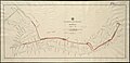 Tremont Street Subway plan, February 1895.jpg 8,360 × 4,072; 8.83 MB
.jpg)


.jpg)
_(19699721590).jpg)
_(19265078324).jpg)
.jpg)
.jpg)
.jpg)
.jpg)
.jpg)
.jpg)
.jpg)
.jpg)
.jpg)
.jpg)
.jpg)
.jpg)
.jpg)
.jpg)
.jpg)
.jpg)
.jpg)
.jpg)
.jpg)
.jpg)
.jpg)
.jpg)
.jpg)
.jpg)
.jpg)
.jpg)
.jpg)
.jpg)
.jpg)
.jpg)
.jpg)
.jpg)
.jpg)
.jpg)
.jpg)
.jpg)
.jpg)
.jpg)
.jpg)
.jpg)
.jpg)
.jpg)
.jpg)
.jpg)
.jpg)
.jpg)
.jpg)
.jpg)
.jpg)
.jpg)

.jpg)
.jpg)
.jpg)
