Category:1895 maps of Oregon
States of the United States: California · Connecticut · Florida · Georgia · Illinois · Indiana · Iowa · Kentucky · Louisiana · Maine · Maryland · Massachusetts · Michigan · Minnesota · Mississippi · Missouri · Nevada · New Jersey · New York · Ohio · Oklahoma · Oregon · Pennsylvania · Rhode Island · South Carolina · Tennessee · Texas · Utah · Vermont · Virginia · Washington · West Virginia · Wisconsin · Wyoming – Washington, D.C.
| ← 1890 1891 1892 1893 1894 1895 1896 1897 1898 1899 |
Subcategories
This category has only the following subcategory.
Media in category "1895 maps of Oregon"
The following 19 files are in this category, out of 19 total.
-
-

-

-

-
-

-

-

-

-
 Astbury's map of Clatsop Co., Ore., Aug. 1895 LOC 2012586244.tif 13,351 × 14,944; 570.82 MB
-

-
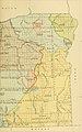
 Map of Lincoln County, Oregon, 1895 LOC 2012586243.jpg 4,772 × 9,559; 6.67 MB
-
 Map of Lincoln County, Oregon, 1895 LOC 2012586243.tif 4,772 × 9,559; 130.51 MB
-

-
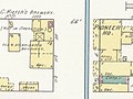
 Sanborn Fire Insurance Map from Albany, Linn County, Oregon. LOC sanborn07313 004-18.jpg 6,450 × 7,650; 2.73 MB
-
 Sanborn Fire Insurance Map from Albany, Linn County, Oregon. LOC sanborn07313 004-3.jpg 6,450 × 7,650; 3.73 MB
-
 Sanborn Fire Insurance Map from Albany, Linn County, Oregon. LOC sanborn07313 004-4.jpg 6,450 × 7,650; 3.17 MB
-
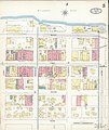
 Sanborn Fire Insurance Map from Corvallis, Benton County, Oregon. LOC sanborn07344 004-9.jpg 6,450 × 7,650; 3.73 MB
-

_1895_map_-_from,_Sanborn_Fire_Insurance_Map_from_Albany,_Linn_County,_Oregon._LOC_sanborn07313_004-3_(cropped).jpg)
.jpg)
_(18739679514).jpg)
_(18741586433).jpg)
_(19174621228).jpg)
_(19176045579).jpg)
_(19356097202).jpg)
_(19366238091).jpg)
_(14594561920).jpg)
_1895_map_-_from,_Sanborn_Fire_Insurance_Map_from_Corvallis,_Benton_County,_Oregon._LOC_sanborn07344_004-9_(cropped).jpg)

.jpg)


,_Linn_Engine_Company_No._2_and_Franklin_Hotel_1895_maps_-_from,_Sanborn_Fire_Insurance_Map_from_Albany,_Linn_County,_Oregon._LOC_sanborn07313_004-4_(cropped).jpg)