Category:18th-century maps of Berkshire
Subcategories
This category has only the following subcategory.
Media in category "18th-century maps of Berkshire"
The following 11 files are in this category, out of 11 total.
-
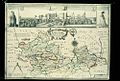 Bodleian Libraries, A New Map of Barkshire.jpg 1,000 × 675; 159 KB
-
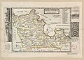
 Bowen - Britannia Depicta (Berkshire).jpg 716 × 1,023; 695 KB
-
 Berk Shire - By H. Moll Geographer - btv1b53056293n.jpg 4,000 × 2,912; 1.88 MB
-

-

-
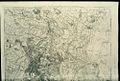 Bodleian Libraries, The First Sheet of an Actual Survey of Berkshire, 1752.jpg 1,000 × 675; 175 KB
-

-

-
 Sandleford, as seen on John Rocque's map of Berkshire, 1761.jpg 2,247 × 2,000; 1.88 MB
-

-
 John Willis map of Sandleford, Berkshire, 1768.jpg 341 × 421; 50 KB

.jpg)


