Category:1900 United States gubernatorial election maps
Media in category "1900 United States gubernatorial election maps"
The following 12 files are in this category, out of 12 total.
-
 1900 Alabama gubernatorial election results map by county.svg 800 × 1,254; 861 KB
-
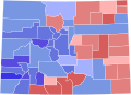 1900 Colorado gubernatorial election results map by county.svg 800 × 579; 36 KB
-
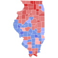 1900 Illinois gubernatorial election results map by county.svg 810 × 810; 30 KB
-

-
 1900 Louisiana gubernatorial election results map by parish.svg 800 × 734; 50 KB
-
 1900 Massachusetts gubernatorial election results map by county.svg 800 × 491; 23 KB
-
 1900 Michigan gubernatorial election results map by county.svg 810 × 810; 43 KB
-
 1900 Minnesota gubernatorial election results map by county.svg 810 × 810; 46 KB
-
 1900 New York gubernatorial election results map by county.svg 744 × 577; 295 KB
-
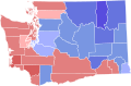 1900 Washington gubernatorial election results map by county.svg 166 × 124; 35 KB
-
 Map of Results of Colorado Gubernatorial Election 1900, by county.png 1,280 × 1,010; 57 KB
-
 USgubernatorial1900.png 2,000 × 1,237; 104 KB


