Category:1904 maps of Montana
States of the United States: Idaho · Illinois · Iowa · Kansas · Louisiana · Maryland · Massachusetts · Michigan · Minnesota · Mississippi · Missouri · Montana · Nebraska · Nevada · New York · North Dakota · Ohio · Pennsylvania · South Dakota · Texas · Utah · Vermont · Washington · Wisconsin – Washington, D.C.
| ← 1904 |
Media in category "1904 maps of Montana"
The following 6 files are in this category, out of 6 total.
-
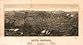
 Billings, Montana, county seat of Yellowstone County 1904. LOC 75694667.jpg 9,056 × 5,632; 6.66 MB
-
 Billings, Montana, county seat of Yellowstone County 1904. LOC 75694667.tif 9,056 × 5,632; 145.92 MB
-
 Billings, Montana. County-seat of Yellowstone County. 1904 LCCN2003680545.jpg 9,810 × 5,911; 7.59 MB
-
-

-
 Montana Presidential Election Results 1904.svg 317 × 184; 18 KB


