Category:1906 maps of Canada
| ← 1900 1901 1902 1903 1904 1905 1906 1907 1908 1909 → |
English: Maps of Canada from 1906 or related to Canada in 1906
Français : Les cartes du Canada de 1906 ou se rapportant au Canada en 1906
Media in category "1906 maps of Canada"
The following 9 files are in this category, out of 9 total.
-
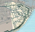 Arrondissement historique du Vieux-Québec.jpg 563 × 522; 214 KB
-

-

-
 GRAND Canal proposal (James Bay to Lake Huron).jpg 715 × 730; 188 KB
-

-
-
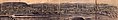 Panorama Montreal 1906.jpg 6,160 × 1,040; 2.17 MB
-
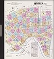
 Quebec City Map 1906.jpg 1,270 × 1,091; 457 KB
-
 Quebec City Map 1906Vieux.jpg 583 × 857; 161 KB

...._-_btv1b532043203.jpg)

.jpg)
,_ao%C3%BBt_1906,_r%C3%A9vis%C3%A9_en_mai_1914_(23148622905).jpg)
,_ao%C3%BBt_1906_(22780642919).jpg)

