Category:1910 maps of Asia
Temperate regions: North America · South America · Africa · Europe · Asia · – Polar regions: – Other regions:
English: 1910 maps of Asia
Español: Mapas de Asia en 1910
Subcategories
This category has the following 9 subcategories, out of 9 total.
.
C
- 1910 maps of China (1 F)
I
- 1910 maps of India (3 F)
- Indo-Chine Franc̜aise (23 F)
J
R
T
- 1910 maps of Turkey (1 F)
U
Media in category "1910 maps of Asia"
The following 20 files are in this category, out of 20 total.
-
-
 Chinese Empire, and Japan (1910).jpg 14,754 × 12,399; 33.5 MB
-
 Keifu Testudō senro ryakuzu; Fu Tōyō Tetsudō senro ryakuzu.jpg 9,782 × 6,967; 11.79 MB
-

-

-

-

-

-

-

-

-

-

-

-

-

-

-
-
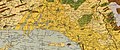
 New geographies (1910) (14803672683).jpg 2,384 × 1,714; 1.16 MB
-
 Shanghai in 1855.tif 3,080 × 3,274; 28.88 MB
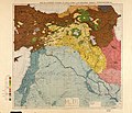
,_%22Chaldeans%22_(7)_and_%22Jacobites%22_(8),_in_Maunsell%27s_map,_Pre-World_War_I_British_Ethnographical_Map_of_eastern_Turkey_in_Asia,_Syria_and_western_Persia_01_(cropped).jpg)
.jpg)

.jpg)
,_Chaldaeans,_and_Jacobites).jpg)
.jpg)
.jpg)

_(14803672683).jpg)
.jpg)
.jpg)
.jpg)
.jpg)
.jpg)
.jpg)
.jpg)
).jpg)
.jpg)
.jpg)