Category:1912 maps of Africa
Temperate regions: North America · South America · Africa · Europe · Asia · – Polar regions: – Other regions:
| ← 1910 1911 1912 1913 1914 1915 1916 1917 1918 1919 → |
Subcategories
This category has the following 2 subcategories, out of 2 total.
E
- 1912 maps of Eritrea (1 F)
S
- 1912 maps of Sudan (2 F)
Media in category "1912 maps of Africa"
The following 10 files are in this category, out of 10 total.
-
 1912 Italian map of the Mediterranean Sea (cropped).jpg 5,256 × 2,748; 2.17 MB
-
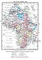 Africa colonial 1912.jpg 1,979 × 2,790; 5.37 MB
-
 Annual report - New York Zoological Society (1912) (17808783314).jpg 3,150 × 2,700; 1.53 MB
-

-

-
 Carte de la Guinée française - Timbo (2e édition) - dressée par A. Meunier... - btv1b531977993.jpg 12,614 × 8,946; 13.33 MB
-
 Haut Sénégal Niger.jpg 2,809 × 3,177; 2.15 MB
-

-

-
 Tsonga map.jpg 432 × 600; 47 KB
.jpg)

_(17808783314).jpg)
_(2a._edi%C3%A7%C3%A0o)_-_Commiss%C3%A3o_de_cartographia_;_M._Diniz,_lith._-_btv1b53197787s.jpg)

_-_dress%C3%A9e_par_A._Meunier..._-_btv1b531977993.jpg)


