Category:1914 maps of Hawaii
States of the United States: California · Hawaii · Idaho · Illinois · Iowa · Kentucky · Louisiana · Massachusetts · Michigan · Minnesota · Missouri · Montana · Nevada · New York · North Dakota · Oklahoma · Pennsylvania · South Dakota · Texas · Vermont · Washington · West Virginia · Wisconsin · Wyoming – Washington, D.C.
| ← 1912 1913 1914 1915 1917 1919 |
Subcategories
This category has the following 6 subcategories, out of 6 total.
S
Media in category "1914 maps of Hawaii"
The following 9 files are in this category, out of 9 total.
-

-

-

-
 Sanborn Fire Insurance Map from Honolulu, Oahu County, Hawaii. LOC sanborn01537 001-10.tif 6,621 × 7,795; 147.66 MB
-
 Sanborn Fire Insurance Map from Honolulu, Oahu County, Hawaii. LOC sanborn01537 001-12.tif 6,621 × 7,795; 147.66 MB
-
 Sanborn Fire Insurance Map from Honolulu, Oahu County, Hawaii. LOC sanborn01537 001-20.tif 6,621 × 7,795; 147.66 MB
-
 Sanborn Fire Insurance Map from Honolulu, Oahu County, Hawaii. LOC sanborn01537 001-21.tif 6,621 × 7,795; 147.66 MB
-
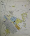
 Sanborn Fire Insurance Map from Laupahoehoe, Hawaii County, Hawaii. LOC sanborn01548 001.jpg 6,510 × 7,707; 3.45 MB
-
 Sanborn Fire Insurance Map from Laupahoehoe, Hawaii County, Hawaii. LOC sanborn01548 001.tif 6,510 × 7,707; 143.55 MB
