Category:1939 maps of Lithuania
Countries of Europe: Croatia · France‡ · Germany · Lithuania · Norway · Poland · Switzerland · Ukraine · United Kingdom
| ← 1930 1933 1935 1936 1938 1939 → |
Media in category "1939 maps of Lithuania"
The following 13 files are in this category, out of 13 total.
-
 Baltic states territorial changes 1939-45 en.svg 1,198 × 1,302; 411 KB
-
 Baltic states territorial changes 1939-45 es.svg 1,198 × 1,302; 411 KB
-
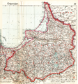
 East Prussia 1939.JPG 752 × 808; 93 KB
-
 Lithuania territory 1939-1940.svg 2,479 × 1,954; 211 KB
-
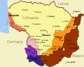
 Memelland 1923-1939.png 733 × 560; 16 KB
-
 Occupation of Poland 1939 (b&w).png 2,481 × 3,355; 1.71 MB
-
 Occupation of Poland 1939.png 2,479 × 3,354; 849 KB
-
 Ostpreussen gelb.jpg 1,772 × 1,908; 441 KB
-
 Ostpreussen RB Westpreussen wiki.PNG 1,772 × 1,908; 399 KB
-
 Ostpreussen.karte.8k.png 6,928 × 7,408; 110.68 MB
-
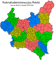 Podz-adm-PL-31-08-1939.PNG 1,337 × 1,473; 126 KB
-
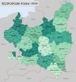 RzeczpospolitaPolska1939.png 4,000 × 4,286; 3.32 MB
-


.png)


