Category:1941 maps of Idaho
States of the United States: Idaho · Illinois · Iowa · Louisiana · Michigan · Nevada · South Dakota · Wisconsin – Washington, D.C.
| ← 1941 1949 |
Media in category "1941 maps of Idaho"
The following 10 files are in this category, out of 10 total.
-
-
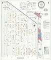
 Sanborn Fire Insurance Map from Dupo, Saint Clair County, Illinois. LOC sanborn01832 003-1.tif 6,450 × 7,650; 141.17 MB
-

-
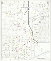
 Sanborn Fire Insurance Map from Dupo, Saint Clair County, Illinois. LOC sanborn01832 003-2.tif 6,450 × 7,650; 141.17 MB
-

-
 Sanborn Fire Insurance Map from Dupo, Saint Clair County, Illinois. LOC sanborn01832 003-3.tif 6,450 × 7,650; 141.17 MB
-

-
 Sanborn Fire Insurance Map from Dupo, Saint Clair County, Illinois. LOC sanborn01832 003-4.tif 6,450 × 7,650; 141.17 MB
-
-
 Sanborn Fire Insurance Map from Dupo, Saint Clair County, Illinois. LOC sanborn01832 003-5.tif 6,450 × 7,650; 141.17 MB


