Category:1944 maps of Taiwan
Countries of Asia: Cambodia · People's Republic of China · India · Indonesia‡ · Japan · Philippines · Thailand · Vietnam
Limited recognition: Taiwan
‡: partly located in Asia
Limited recognition: Taiwan
‡: partly located in Asia
| ← 1940 1941 1942 1944 1945 1946 1949 → |
Media in category "1944 maps of Taiwan"
The following 16 files are in this category, out of 16 total.
-
 AAF Cloth Chart - Asiatic Series, No. 34, Southeast China.jpg 1,936 × 2,563; 1.99 MB
-
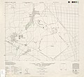
 Chikunan 1 8000 1944.jpg 3,972 × 3,992; 3.13 MB
-
 Fb141223173524-page-001.jpg 1,484 × 1,174; 320 KB
-
 Formosa (Taiwan) Roads - NARA - 140696134.jpg 12,608 × 16,365; 13.77 MB
-
 Kato 1 10000 1944.jpg 4,358 × 3,988; 3.16 MB
-

-
 Operation-Causeway-Phase-1.jpg 2,873 × 3,078; 339 KB
-
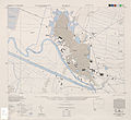
 Rato 1 6000 1944.jpg 4,352 × 3,972; 3.48 MB
-
 Rokko 1 6000 1944.jpg 4,362 × 3,982; 3.63 MB
-
 Suo 1 10000 1944.jpg 3,964 × 4,388; 4.98 MB
-
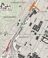
 Tainan Airport (1944).jpg 1,891 × 2,175; 1.01 MB
-
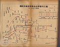
 Tainan Province Administrative Chart.jpg 994 × 1,102; 323 KB
-
 Town Plan of Tainan - DPLA - bf5f5c81ec2a62d6f642d380204757d8.jpg 12,352 × 9,595; 5.94 MB
-
 大公路橋位置圖.png 521 × 631; 716 KB
-
 大溪街地圖.jpg 1,191 × 834; 704 KB
-
 柴頭港溪流域圖-02.png 2,691 × 2,968; 5.98 MB


_Roads_-_NARA_-_140696134.jpg)

_on_March_27,_1944_(30583362020)_(cropped).jpg)


.jpg)


