Category:1950 maps of the world
Media in category "1950 maps of the world"
The following 14 files are in this category, out of 14 total.
-
 1900 - Britannia's World.jpg 1,095 × 1,152; 320 KB
-
 1950 International Trade (30583518780).jpg 1,366 × 876; 501 KB
-

-
-
 Do more people live in urban or rural areas., OWID.svg 850 × 600; 139 KB
-

-
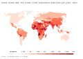
 Life expectancy in 1800, 1950, and 2015.png 3,000 × 4,323; 1.33 MB
-
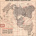 North polar Azimuthal equidistant map, 1950.jpg 2,117 × 2,102; 852 KB
-

-
 The commonwealth of nations, 1950.jpg 3,590 × 2,235; 2.3 MB
-
 The World - DPLA - 8e439e5657b1e933f180f57f31bb0ea4.jpg 11,963 × 7,141; 8.36 MB
-
 Two Worlds.jpg 7,477 × 5,059; 14.93 MB
-
 World freedom - a factual & pictorial map.tif 12,957 × 5,638; 209.03 MB
-
 World Freedom map by Ernest Dudley Chase 1950.jpg 2,000 × 870; 1.84 MB

.jpg)


.jpg)