Category:1960 maps of the United States
Countries of the Americas: Cuba · United States of America
States of the United States: California · Hawaii · Massachusetts · Michigan · New York · Pennsylvania · Virginia – Washington, D.C.
Subcategories
This category has the following 9 subcategories, out of 9 total.
C
- 1960 maps of California (1 F)
D
H
M
- 1960 maps of Massachusetts (3 F)
- 1960 maps of Michigan (1 F)
N
P
- 1960 maps of Pennsylvania (1 F)
V
- 1960 maps of Virginia (2 F)
Media in category "1960 maps of the United States"
The following 4 files are in this category, out of 4 total.
-
 1960 census map.png 5,285 × 3,762; 1.32 MB
-
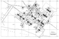 CCAFS Industrial Area, 1960 map.png 1,400 × 933; 253 KB
-
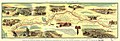 Pony express route April 3, 1860 - October 24, 1861 LOC 2004629238.jpg 8,857 × 3,006; 3.08 MB
-
 Pony express route April 3, 1860 - October 24, 1861 LOC 2004629238.tif 8,857 × 3,006; 76.17 MB

