Category:1960s maps of the Iberian Peninsula
| 20th-century maps of the Iberian Peninsula: ← 1900s 1910s 1920s 1930s 1940s 1950s 1960s 1970s 1980s 1990s → |
Subcategories
This category has the following 2 subcategories, out of 2 total.
P
S
Media in category "1960s maps of the Iberian Peninsula"
The following 2 files are in this category, out of 2 total.
-
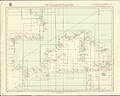 Admiralty Chart Catalogue 1967 Page 032 Index E.jpg 8,568 × 6,820; 9.91 MB
-


_(20393050095).jpg)