Category:1970s maps of Africa
Temperate regions: North America · South America · Africa · Europe · Asia · Oceania – Polar regions: – Other regions:
Subcategories
This category has the following 37 subcategories, out of 37 total.
- 1975 maps of Africa (3 F)
A
B
C
D
E
- 1970s maps of Egypt (10 F)
K
L
M
- 1970s maps of Madagascar (2 F)
N
S
- 1970s maps of Senegal (3 F)
T
U
Z
- 1970s maps of Zimbabwe (4 F)
Media in category "1970s maps of Africa"
The following 8 files are in this category, out of 8 total.
-
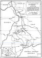 Cameroon-Chad boundary map.png 766 × 1,064; 277 KB
-
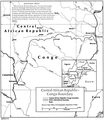 CAR-PR Congo border map.png 835 × 951; 264 KB
-
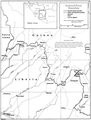 Guinea-Liberia border map.png 870 × 1,145; 305 KB
-
 Liberia Sierra Leone border.png 848 × 1,166; 261 KB
-
 Map of the Central African Republic-Cameroon border.png 716 × 1,002; 290 KB
-
 Niger-Nigeria border map.png 1,358 × 988; 173 KB
-
 Nile River (PSF).png 3,516 × 3,120; 576 KB
-
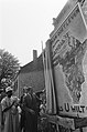 Prins Claus onthult een kaart van Afrika, Bestanddeelnr 928-1105.jpg 2,441 × 3,680; 1.43 MB


.png)
