Category:1970s maps of Denver, Colorado
Media in category "1970s maps of Denver, Colorado"
The following 24 files are in this category, out of 24 total.
-
 City and county of Denver, annexation map - DPLA - 511b1906cb439b0b0865e3fdb1c0c9ed.jpg 9,000 × 7,311; 6.36 MB
-
-

-

-
 Cheesman Park, Revised Facility Map - DPLA - 4b0f506f8e7357a06fcb53c7b497e43d.jpg 9,000 × 4,427; 3.72 MB
-
 Elementary school boundaries Denver, Colorado - DPLA - 6ab130d5a20713adfb28decc760904b6.jpg 9,000 × 6,851; 7.07 MB
-
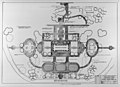
 Proposed PRT demonstration site - DPLA - 6f752c23cb5a2c7c00b67f23dd85ff40.jpg 6,943 × 3,140; 2.61 MB
-

-

-

-
 City and county of Denver, annexation map - DPLA - 929e6edbfb91d9b7e0cb3f78f7ae5a2a.jpg 9,000 × 8,931; 4.05 MB
-
 Cheesman Park Facility map - DPLA - e26f189c1fbd163689420d1d837e2e96.jpg 8,999 × 5,944; 3.8 MB
-
 Eisenhower Park Base Map - DPLA - 75a72de525cf78a6afeaf0a11009f3aa.jpg 7,000 × 4,458; 1.73 MB
-
 Denver bikeway system - DPLA - 7924eae90a3c72a2e9115f70f03401c6.jpg 9,000 × 5,778; 7.64 MB
-
 Early action bus program - DPLA - 2538e71239d14520eb9a370c65fed7a4.jpg 7,129 × 9,000; 4.31 MB
-

-
 Park Hill Golf, Schematic Development Plan - DPLA - 0ab9bc69fddfb6c298920429f9949488.jpg 8,437 × 6,005; 3.6 MB
-

-
 Denver bicycle map - DPLA - ca4d95ee97434bc4a5738bac2271dce7.jpg 9,000 × 7,505; 10.16 MB
-
 Development of Denver 1865 to present - DPLA - d62f512722f2aa3528f5e693673c65c4.jpg 8,999 × 6,370; 3.81 MB
-

-
 Plan for roadways in Cheesman Park - DPLA - 3084d67aff045cd35f89711c5713f7e5.jpg 8,999 × 6,619; 3.99 MB
-

-
 Map of the People's Fair 1977 - DPLA - 7f1b8f1a174dc0a3da7aa37dc692f502.jpg 9,000 × 6,205; 3.61 MB


.jpg)
.jpg)
.jpg)


