Category:1982 maps of Massachusetts
States of the United States: Arkansas · California · Florida · Massachusetts · Oklahoma · Pennsylvania · South Carolina · Texas · Virginia
| ← 1980 1981 1982 1985 1986 1987 1988 |
Media in category "1982 maps of Massachusetts"
The following 24 files are in this category, out of 24 total.
-
 Boston National Historical Park, Massachusetts LOC 83690286.jpg 5,024 × 9,432; 7.05 MB
-
 Boston National Historical Park, Massachusetts LOC 83690286.tif 5,024 × 9,432; 135.57 MB
-
 Cape Cod National Seashore, Massachusetts LOC 86694817.jpg 5,053 × 7,076; 4.6 MB
-
 Cape Cod National Seashore, Massachusetts LOC 86694817.tif 5,053 × 7,076; 102.3 MB
-
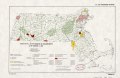
 Massachusetts, conservation planning and application, 1982 LOC 82696199.jpg 5,052 × 3,297; 2 MB
-
 Massachusetts, conservation planning and application, 1982 LOC 82696199.tif 5,052 × 3,297; 47.65 MB
-
 Status of flood plain identification as of January 1, 1982 - Massachusetts LOC 82696206.jpg 5,067 × 3,295; 2.43 MB
-
 Status of flood plain identification as of January 1, 1982 - Massachusetts LOC 82696206.tif 5,067 × 3,295; 47.77 MB
-

-

-
 Status of important farmlands maps as of January 1, 1982 - Massachusetts LOC 82696203.jpg 4,683 × 3,154; 1.84 MB
-
 Status of important farmlands maps as of January 1, 1982 - Massachusetts LOC 82696203.tif 4,683 × 3,154; 42.26 MB
-

-
-
 Status of resource studies as of January 1, 1982 - Massachusetts LOC 82696200.jpg 5,069 × 3,294; 2.11 MB
-
 Status of resource studies as of January 1, 1982 - Massachusetts LOC 82696200.tif 5,069 × 3,294; 47.77 MB
-
 Status of soil surveys as of January 1, 1982 - Massachusetts LOC 82696201.jpg 5,073 × 3,294; 2.03 MB
-
 Status of soil surveys as of January 1, 1982 - Massachusetts LOC 82696201.tif 5,073 × 3,294; 47.81 MB
-

-

-

-

-

-


