Category:1988 United States gubernatorial election maps
Media in category "1988 United States gubernatorial election maps"
The following 16 files are in this category, out of 16 total.
-
 1988 United States gubernatorial elections results map.svg 959 × 593; 80 KB
-
 1988 Indiana gubernatorial election results map by county.svg 810 × 810; 35 KB
-
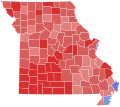 1988 Missouri gubernatorial election results map by county.svg 810 × 717; 49 KB
-
 1988 Montana gubernatorial election results map by county.svg 744 × 442; 485 KB
-
 1988 New Hampshire gubernatorial election results map by county.svg 810 × 810; 14 KB
-

-
 1988 North Carolina gubernatorial election results map by county.svg 426 × 173; 40 KB
-
 1988 North Dakota gubernatorial election results map by county.svg 273 × 163; 32 KB
-
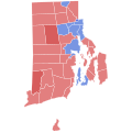
 1988 Rhode Island gubernatorial election results map by county.svg 810 × 810; 13 KB
-
-
 1988 Utah gubernatorial election results map by county.svg 810 × 810; 29 KB
-
 1988 Vermont gubernatorial election results map by county.svg 810 × 810; 17 KB
-
 1988 Vermont gubernatorial election results map by municipality.svg 810 × 810; 105 KB
-
 1988 Washington gubernatorial election results map by county.svg 810 × 535; 61 KB
-
 1988 West Virginia gubernatorial election results map by county.svg 810 × 719; 38 KB
-
 Delaware Governor Election Results by County, 1988.svg 810 × 810; 6 KB


