Category:19th-century maps of Chicago
Subcategories
This category has the following 7 subcategories, out of 7 total.
- 1830s maps of Chicago (15 F)
- 1840s maps of Chicago (4 F)
- 1850s maps of Chicago (17 F)
- 1860s maps of Chicago (18 F)
- 1870s maps of Chicago (39 F)
- 1880s maps of Chicago (16 F)
Media in category "19th-century maps of Chicago"
The following 7 files are in this category, out of 7 total.
-
 Chicago in 1812 Andreas (cropped1a).png 509 × 419; 333 KB
-
 Chicago in 1812 Andreas.png 3,600 × 2,102; 12.86 MB
-

-
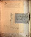
 1821 Survey Chicago 46a.jpg 2,753 × 3,331; 2.3 MB
-
 1821 Survey Chicago 46b.jpg 2,753 × 3,344; 2.23 MB
-
 1822 Survey Chicago 47b.jpg 2,768 × 3,330; 2.06 MB
-

.png)

.jpg)


.jpg)