Category:19th-century maps of Copenhagen
Subcategories
This category has the following 2 subcategories, out of 2 total.
1
- 1807 maps of Copenhagen (4 F)
C
Media in category "19th-century maps of Copenhagen"
The following 60 files are in this category, out of 60 total.
-
 København Kvarterkort 1800 NatMus.jpg 3,773 × 5,011; 14.95 MB
-
 Map of Copenhagen 1800.jpg 5,000 × 3,519; 1.64 MB
-
 Rawerts Brandkort no. 15.jpg 1,150 × 1,008; 196 KB
-
 Grundriss der Stadt und Festung Kopenhagen und der umliegenden Gegend.jpg 4,920 × 4,888; 8.45 MB
-
 Werming Malmö och Köpenhamn.png 4,022 × 3,100; 9.87 MB
-
 Arbejder fra den Botaniske have i København (19126704834).jpg 1,844 × 2,558; 1.29 MB
-
 Arbejder fra den Botaniske have i København (19753908961).jpg 2,598 × 1,872; 1.48 MB
-
 Grundtegning af Kiöbenhavn 1831 - no-nb krt 00767.jpg 9,258 × 6,134; 24.21 MB
-
 Grundtegning af Kiøbenhavn 1831.png 2,000 × 1,369; 1.46 MB
-
 Europa - no-nb krt 01012.jpg 8,082 × 10,800; 26.16 MB
-
 Copenhagen old haymarket 1837.jpg 540 × 375; 58 KB
-
 Gammelholm c. 1840.jpg 560 × 341; 67 KB
-
 Snarens Qvarteer 1840.png 723 × 654; 682 KB
-
 Rosenborg Qvarteer 1841.png 590 × 892; 826 KB
-
 Østerbro 1841 map detail.jpg 751 × 800; 150 KB
-
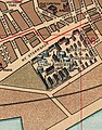
 Botanisk Have plan 1847.jpg 1,000 × 698; 338 KB
-
 1849 Copenhagen public libraries map HouseOfCommonsSelectCommittee.jpg 610 × 376; 136 KB
-
 Copenhagen circa 1850.jpg 1,024 × 985; 1.07 MB
-
 Kaart over Kjøbenhavn - no-nb krt 00771.jpg 8,820 × 7,579; 20.66 MB
-
 Map of Copenhagen c. 1850.jpg 500 × 481; 136 KB
-
 Plan for Gammelholm 1852 by Conrad Seidelin.jpg 4,332 × 3,730; 2.81 MB
-
 Plan af Kjöbenhavn = Plan of Copenhagen LOC 2012593340.jpg 6,701 × 4,434; 4.64 MB
-
 Plan af Kjöbenhavn = Plan of Copenhagen LOC 2012593340.tif 6,701 × 4,434; 85.01 MB
-
 Sundbyerne, 1854.jpg 540 × 641; 84 KB
-
 Copenhagen (1856).jpg 400 × 292; 53 KB
-
 Ewaldsgade (Brogade) 1856.png 600 × 795; 880 KB
-
 Grundtegning af Gammelholm 1856.png 1,280 × 1,173; 1.68 MB
-
 Kopenhagen map 1860.jpg 1,544 × 1,025; 322 KB
-
 Nørrevold (1856).jpg 1,325 × 1,600; 1 MB
-
 Outside Østerport - Farimagsvejen.jpg 500 × 541; 67 KB
-
 Plan for the Expansion of Copenhagen 1857 by Conrad Seidelin.djvu 5,412 × 4,406; 4.3 MB
-
 Plan for the Expansion of Copenhagen 1857 by Conrad Seidelin.jpg 5,412 × 4,406; 5.82 MB
-
 Vodroffsgård map detail 1857.jpg 600 × 496; 95 KB
-
 Kastellet 1859.djvu 4,007 × 3,307; 1.25 MB
-
 Kastellet 1859.jpg 4,007 × 3,307; 2.99 MB
-
 Ryesgade (1860).jpg 835 × 289; 351 KB
-
 Ferdinand Meldahls nedrivningsplan for Nyboder.jpg 650 × 470; 42 KB
-
 Outer Nørrebro map detail 1868.jpg 546 × 338; 235 KB
-
 Copenhagen Botanical Garden plan 1870.jpg 800 × 518; 430 KB
-

-

-
 Meyers b10 s0060a.jpg 2,048 × 1,666; 782 KB
-
 Meyers b10 s0061 b1.png 513 × 790; 220 KB
-
 Admiralty Chart No 2115 Entrance to the Baltic The Sound, Published 1886.jpg 8,318 × 12,168; 16.29 MB
-
 COP1887 MAP COPENHAGEN and its Environs 1886.jpg 3,843 × 3,604; 3.59 MB
-
 Istedgade - 1886 map detail.jpg 660 × 673; 473 KB
-
 Den nordiske udstilling i 1888.jpg 500 × 455; 55 KB
-
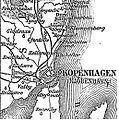
 Karte Kopenhagen MKL1888.jpg 2,048 × 1,666; 599 KB
-
 København1888 nu bygrænse.JPG 257 × 260; 27 KB
-
 Langebro1888.jpg 253 × 250; 28 KB
-
 Langebro1888v2.jpg 483 × 506; 77 KB
-
 Halmtorvet (Ny Stormgade) map detail.jpg 535 × 681; 391 KB
-
 Denmark; its medical organization, hygiene and demography (1891) (14586949517).jpg 2,982 × 2,386; 1.29 MB
-
 Denmark; its medical organization, hygiene and demography (1891) (14750420686).jpg 3,362 × 2,114; 1,011 KB
-
 Eberts Villaby (Franz Sedivy) (2).jpg 871 × 591; 261 KB
-
 Valby 1896.jpg 2,000 × 1,454; 1.05 MB
-
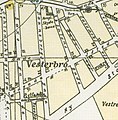
 Vesterbro map 1896.jpg 2,000 × 1,454; 886 KB
-
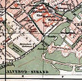
 Østerbro map 1896.jpg 1,454 × 2,000; 982 KB
-

-
 Map of Copenhagen 1844.jpg 8,656 × 7,186; 23.52 MB


.jpg)
.jpg)


.jpg)
_1856.png)


.jpg)


_p1.066_Karte_von_Befestigungsanlagen_der_Umgebung_von_Kopenhagen,_1658.jpg)


_map_detail.jpg)
_(14586949517).jpg)
_(14750420686).jpg)
_(2).jpg)


%27_(11247229183)_cropped.jpg)

.jpg)