Category:19th-century maps of Jerusalem
Subcategories
This category has the following 4 subcategories, out of 4 total.
- 1850s maps of Jerusalem (22 F)
- 1870s maps of Jerusalem (12 F)
- 1880s maps of Jerusalem (16 F)
Media in category "19th-century maps of Jerusalem"
The following 102 files are in this category, out of 102 total.
-

-
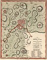 John Melish. The Land of Moriah or Jerusalem and the Adjacent Country. 1815.jpg 4,287 × 5,479; 17.65 MB
-

-

-
 James Silk Buckingham, Plan of the modern Jerusalem (FL6879044 2369659).jpg 2,750 × 2,241; 2.65 MB
-

-

-

-

-

-

-

-

-

-

-

-

-

-
 81 of 'Walks about the City and Environs of Jerusalem. (Second edition.)' (11024087375).jpg 2,736 × 3,548; 1.36 MB
-

-

-
 217 of 'Buried Cities and Bible Countries' (11298370556).jpg 1,325 × 1,085; 486 KB
-
 265 of 'Buried Cities and Bible Countries' (11213822364).jpg 1,325 × 1,953; 536 KB
-
 277 of 'Buried Cities and Bible Countries' (11213118743).jpg 1,325 × 2,191; 777 KB
-
 282 of 'Buried Cities and Bible Countries' (11298379063).jpg 1,325 × 1,431; 319 KB
-
 348 of 'Buried Cities and Bible Countries' (11299053753).jpg 1,052 × 1,022; 149 KB
-
 203 of 'The Fifth Gospel, the land where Jesus lived' (11220328704).jpg 1,160 × 1,845; 838 KB
-

-
-
 CUINET(1896) JERUSALEM.jpg 2,378 × 3,295; 4.63 MB
-

-
 13 of 'Calvary and the Tomb' (11253695253).jpg 1,478 × 1,707; 609 KB
-
 Charles Foster Kent, The Jerusalem of Nehemah (1899) (14596514630).jpg 2,008 × 2,620; 734 KB
-
 MACCOUN(1899) p219 AL KUDS - JERUSALEM OF TO-DAY.jpg 1,963 × 3,372; 3 MB
-
 HOPKINS(1899) p019 GONDER'S TOMB (discovered 1881 by Major Conder).jpg 1,085 × 996; 482 KB
-
 HOPKINS(1899) p013 MAP OF JERUSALEM.jpg 443 × 587; 213 KB
-

-

-

-

-

-

-
 715 of 'Cities of the World- their origin, progress ... Illustrated' (11143432916).jpg 1,845 × 2,187; 1.46 MB
-

-
 Ancient Jerusalem Modern Jerusalem (cropped).jpg 624 × 643; 446 KB
-
 Ancient Jerusalem Modern Jerusalem.jpg 1,485 × 1,094; 1.21 MB
-
-

-
 Carte de la Terre Sainte - Dresse et Gravee par P. Tardieu.jpg 2,849 × 2,200; 2.92 MB
-
 Descripcion de la antigua Jerusalem, y de sus immediaciones.jpg 2,704 × 2,300; 2.72 MB
-
 Descriptio seu ichnographia veteris urbis Hierusalem et locorum adjacentium.jpg 2,800 × 2,199; 3.85 MB
-
 Die Stadt Jerusalem aus der Vogelschau.jpg 2,800 × 2,212; 2.94 MB
-

-
 Four holy cities plaque.jpg 640 × 436; 66 KB
-
 Frederick Catherwood. Plan of Jerusalem. 1835.jpg 3,354 × 4,265; 13.49 MB
-
 Frederick Catherwood00.jpg 2,140 × 2,925; 1.18 MB
-
 Handbook map of Jerusalem Reduced from the Ordnance Survey - Edwd. Weller.jpg 1,101 × 1,134; 328 KB
-
 Haram-al-sharif-plan-1890.jpg 909 × 847; 135 KB
-

-

-
 Jerusalem in the time of Christ (FL36567431 3909081).jpg 2,157 × 3,289; 3.26 MB
-
 Jerusalem with its environs - draw and engraved by Thomas Starling - btv1b53119281d.jpg 7,064 × 9,429; 8.66 MB
-
 Jerusalem-Measurment-map-German .jpg 1,697 × 1,180; 391 KB
-
 Le Tour du monde-01-p392.jpg 834 × 762; 235 KB
-
 Le Tour du monde-01-p411.jpg 834 × 1,262; 420 KB
-
 Map of Palestine (1898).jpg 2,906 × 4,492; 2 MB
-
 Meyers b9 s0200 b1.png 765 × 810; 301 KB
-
 Meyers b9 s0203 b1.png 392 × 601; 115 KB
-
-
 Ordnance Survey of Jerusalem - btv1b530987298.jpg 7,742 × 9,475; 15.22 MB
-
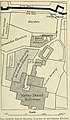
 Ordnance Survey of Jerusalem. Plan of David's Tomb.jpg 1,534 × 1,400; 311 KB
-
 Ordnance Survey of Jerusalem. Plan of the Armenian Chapel in the Convent of St James.jpg 1,788 × 1,803; 551 KB
-
 Ordnance Survey of Jerusalem. Plan of the Citadel (Al Kala) - btv1b84924098.jpg 11,440 × 8,266; 11.01 MB
-
 Ordnance Survey of Jerusalem. Plan of the Citadel (cropped).jpg 4,788 × 6,643; 5.25 MB
-
 Ordnance Survey of Jerusalem. Plan of the Greek Church in the Convent of the Cross.jpg 1,221 × 1,311; 242 KB
-
 Ordnance Survey of Jerusalem. Plan of the House of Caiaphas.jpg 1,957 × 1,399; 369 KB
-
-

-
 Plan der Strassen & Plätze des jetzigen Jerusalem - von Dr. C.Sandreczki.jpg 2,500 × 2,450; 2.22 MB
-

-

-
 Plan of Jerusalem.jpg 2,100 × 2,932; 2.92 MB
-
-

-

-

-

-
-
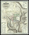
 Plan von Jerusalem nach den Untersuchungen. 1845.jpg 10,212 × 13,600; 23.35 MB
-
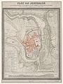
 Plan von jerusalem von albert schaffter 1849.jpg 1,616 × 2,529; 1,016 KB
-

-
 Prospect der stadt Jerusalem vom Oelberge.jpg 3,000 × 2,078; 2.61 MB
-
 RC schick 1894.jpg 800 × 831; 237 KB
-

-

-

-
 Topographischer Plan von Jerusalem - Im Jahre 1837.jpg 2,220 × 2,747; 3.28 MB
-
 Toussaint, A. Carte de la Palestine. 1834.C.jpg 893 × 1,267; 213 KB
-
-
 PEF D031 shick notes on excavating mount zion.png 3,111 × 2,615; 348 KB
-
 Древній и Современный Іерусалимъ - "Брокгауза и Ефрона".jpg 1,820 × 3,365; 5.31 MB
-
 План Іерусалима - снятый Катервудомъ в 1835.jpg 2,840 × 3,903; 1.45 MB
_(With_plates,_including_a_portrait.)%27_(11001678446).jpg)

)%27_(11005418344).jpg)
)%27_(11005493873).jpg)
.jpg)
)%27_(11005453734).jpg)
)%27_(11005376383).jpg)
%27_(11220812606).jpg)
.jpg)
.jpg)
%27_(11226660916).jpg)
%27_(11007187906).jpg)
%27_(11022680584).jpg)
%27_(11007602595).jpg)
%27_(11007273345).jpg)
%27_(11227742723).jpg)
.jpg)
%27_(11024087375).jpg)
%27_(11030175144).jpg)
_et_de_Saulcy_(Voyage_en_Terre_Sainte).jpg)
.jpg)
.jpg)
.jpg)
.jpg)
.jpg)
.jpg)
.jpg)
_(14776331812).jpg)
_JERUSALEM.jpg)
.jpg)
.jpg)
_(14596514630).jpg)
_p219_AL_KUDS_-_JERUSALEM_OF_TO-DAY.jpg)
_p019_GONDER%27S_TOMB_(discovered_1881_by_Major_Conder).jpg)
_p013_MAP_OF_JERUSALEM.jpg)
.jpg)
.jpg)
.jpg)
%27_(11149511576).jpg)
.jpg)
.jpg)

.jpg)

.jpg)


.jpg)


.jpg)


.jpg)


_-_btv1b84924098.jpg)
.jpg)


.jpg)
.jpg)


_(14592538058).jpg)


%27_(11006896716).jpg)
%27_(11226987936).jpg)