Category:19th-century maps of Thailand
Subcategories
This category has only the following subcategory.
Media in category "19th-century maps of Thailand"
The following 22 files are in this category, out of 22 total.
-

-

-
 1843 map of China and the Birman Empire wih parts of Cochin-China and Siam by the SDUK.jpg 9,408 × 7,923; 12.86 MB
-
 Carte-du-royaume-de-Siam-1854.jpg 903 × 1,293; 700 KB
-
 Admiralty Chart No 2414 Gulf of Siam, Published 1855, Corrections to 1858.jpg 3,778 × 5,000; 4.43 MB
-
 Map of lower Cochinchina and Cambodia 1863 contrast adjusted.jpg 1,180 × 1,720; 914 KB
-
 IndoChina1867.jpg 4,456 × 3,677; 8.78 MB
-
 1886 Bangkok detail of Indo China map in Scottish Geographical Magazine.png 1,262 × 683; 1.8 MB
-
 Cambodia indochina map 1886.jpg 758 × 529; 197 KB
-

-

-
 Siam in 1893, During Rama V's Reign.jpg 10,000 × 15,000; 7.56 MB
-
-

-

-

-

-
 DongDuong1883.jpg 2,030 × 2,790; 1.46 MB
-

-
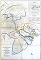
 Rattanakosin (Chakri) - Đại Nam (Nguyễn) war map.jpg 3,382 × 3,088; 514 KB
-
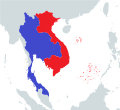 Rattanakosin (Chakri) - Đại Nam (Nguyễn) war map.svg 512 × 467; 478 KB
-
 Southeast Asia, Birman Empire & Countries South and East of the Ganges, 1831.jpg 8,558 × 10,328; 5.28 MB
.jpg)
_-_Geographicus_-_EastIndies-cary-1801.jpg)


.jpg)
.jpg)

_(14796560713).jpg)
.jpg)
.jpg)
.jpg)
.jpg)

_by_James_Low.jpg)
_-_%C4%90%E1%BA%A1i_Nam_(Nguy%E1%BB%85n)_war_map.jpg)
_-_%C4%90%E1%BA%A1i_Nam_(Nguy%E1%BB%85n)_war_map.svg)
