Category:19th-century maps of the Canary Islands
Subcategories
This category has only the following subcategory.
Media in category "19th-century maps of the Canary Islands"
The following 8 files are in this category, out of 8 total.
-

-
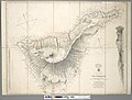
 Admiralty Chart No 1850 Canary Islands - Fuerteventura, Published 1848.jpg 5,966 × 8,418; 12.93 MB
-
 Admiralty Chart No 1852 Canary Islands - Lanzarote, Published 1848.jpg 5,981 × 8,400; 9.68 MB
-
 Admiralty Chart No 1870 Tenerife - Canary Islands, Surveyed 1838.jpg 8,197 × 6,225; 14.04 MB
-
 Admiralty Chart No 1873 Palma, Gomera and Hierro Or Ferro 1861, Published 1861.jpg 8,218 × 6,205; 12.5 MB
-
 Admiralty Chart No 1873 Palma, Gomera and Hierro Or Ferro, Published 1848.jpg 8,040 × 6,205; 12.54 MB
-
 Admiralty Chart No 1894 The Canary Islands, Published 1848.jpg 8,181 × 6,182; 11.12 MB
-
 Islas Canarias 1849.jpg 12,977 × 9,541; 15.69 MB
.jpg)


