Category:19th century maps of Indre
Subcategories
This category has only the following subcategory.
Media in category "19th century maps of Indre"
The following 4 files are in this category, out of 4 total.
-

-
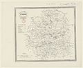 Carte du département de l'Indre - 1838.jpg 5,462 × 4,504; 2.57 MB
-
 Carte du département de l'Indre - 1862.jpg 10,416 × 7,688; 12.02 MB
-
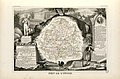 Dépt. de l'Indre (région du centre) - Fonds Ancely - B315556101 A LEVASSEUR 039.jpg 3,079 × 2,033; 2.08 MB
_-_Geographicus_-_Indre-levasseur-1852.jpg)


_-_Fonds_Ancely_-_B315556101_A_LEVASSEUR_039.jpg)