Category:19th century topographic maps of Jura (department)
Media in category "19th century topographic maps of Jura (department)"
The following 5 files are in this category, out of 5 total.
-
 Carte d'État-major de la France, Feuille Fernex N.O.jpg 23,622 × 13,729; 68.3 MB
-
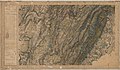
 Carte d'État-major de la France, Feuille Saint-Claude N.E.jpg 23,409 × 13,638; 111.46 MB
-
 Carte d'État-major de la France, Feuille Saint-Claude N.O.jpg 23,409 × 13,736; 107.78 MB
-
 Carte d'État-major de la France, Feuille Saint-Claude S.E.jpg 23,409 × 13,633; 111.88 MB
-
 Carte d'État-major de la France, Feuille Saint-Claude S.O.jpg 23,409 × 13,626; 108.11 MB


